Land For Sale £628,000
Summary
A rare opportunity to purchase several sites of prime development land as a whole or separately (Blocks 1,2 and 3) with outline planning permission
granted (P/2016/0893), (P/2017/1236) and (18/0395/out), for the erection of 19 dwellings (including 6 affordable) situated in the village of Castle
Caereinion a short drive from the market town of Welshpool. The village has a wonderful sense of community with a church, primary school, village
shop/post office and a public house. Llanfair Caereinion is approximately 4 miles away which has a doctor’s surgery and high school. Viewing for this
exciting development opportunity is highly recommended.
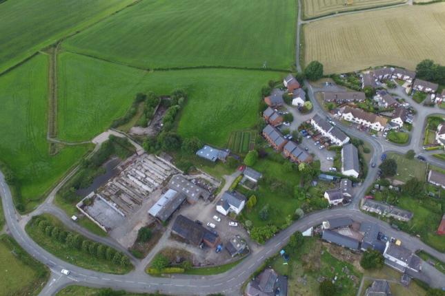
Site location
Castle Caereinion is a delightful village conveniently located just off the A458 about 4.5 miles West of the market town of Welshpool. The village has a
wonderful sense of community with a church, primary school, village shop/post office and a public house. Llanfair Caereinion is approximately 4 miles
away which has a high school and a doctor’s surgery.
Further information
A full information pack can be made available on request from the selling agent which includes planning drawings and site plans.
Viewings
All viewings must be arranged in advance with the selling agent using the details provided below.
Local authority
Powys County Council.
Site description
The site extends to approximately 0.3 hectares (0.74 acres) of village edge land, which is currently in agricultural use. The site is located on the West side
of the village and is fairly flat with mains water, sewerage and electricity nearby. A new access is proposed from the B4385.
Planning status
Outline planning permission was granted on 12th May 2017 for 5 residential units, to include 1 affordable unit. A full planning pack can be obtained from
the Agents on request or viewed online at:
Services & tenure
The village benefits from mains water, sewage and electric. Freehold title is being sold, with the benefit of vacant possession upon completion.
Site description
The site covers approximately 0.98 hectares (2.42 acres) of village edge land, which is currently in agricultural use. The site is located on the North West
side of the village and is fairly flat with mains water, sewerage and electricity nearby. A new access is proposed from the B4385.
Planning status
Outline planning permission was granted on 15th March 2018 for 9 residential units with garages, to include 4 affordable units. A full planning pack can
be obtained from the Agents on request or viewed online at:
Services & tenure
The village benefits from mains water, sewage and electric. Freehold title is being sold, with the benefit of vacant possession upon completion.
Site 3 – Development Land (Outline Planning for 5 Units)
Site description
The site covers approximately 0.60 hectares (1.48 acres) of village edge land, which is currently in agricultural use. The site is located on the North West
side of the village and is fairly flat with mains water, sewerage and electricity nearby. A new access is proposed from the B4385.
Planning status
Outline planning permission was granted on 16th January 2019 for 5 residential units with garages, to include 1 affordable unit. A full planning pack can
be obtained from the Agents on request or viewed online at:
Services & tenure
The village benefits from mains water, sewage and electric. Freehold title is being sold, with the benefit of vacant possession upon completion.
A rare opportunity to purchase several sites of prime development land as a whole or separately (Blocks 1,2 and 3) with outline planning permission
granted (P/2016/0893), (P/2017/1236) and (18/0395/out), for the erection of 19 dwellings (including 6 affordable) situated in the village of Castle
Caereinion a short drive from the market town of Welshpool. The village has a wonderful sense of community with a church, primary school, village
shop/post office and a public house. Llanfair Caereinion is approximately 4 miles away which has a doctor’s surgery and high school. Viewing for this
exciting development opportunity is highly recommended.
Site location
Castle Caereinion is a delightful village conveniently located just off the A458 about 4.5 miles West of the market town of Welshpool. The village has a
wonderful sense of community with a church, primary school, village shop/post office and a public house. Llanfair Caereinion is approximately 4 miles
away which has a high school and a doctor’s surgery.
Further information
A full information pack can be made available on request from the selling agent which includes planning drawings and site plans.
Viewings
All viewings must be arranged in advance with the selling agent using the details provided below.
Local authority
Powys County Council.
Site description
The site extends to approximately 0.3 hectares (0.74 acres) of village edge land, which is currently in agricultural use. The site is located on the West side
of the village and is fairly flat with mains water, sewerage and electricity nearby. A new access is proposed from the B4385.
Planning status
Outline planning permission was granted on 12th May 2017 for 5 residential units, to include 1 affordable unit. A full planning pack can be obtained from
the Agents on request or viewed online at:
Services & tenure
The village benefits from mains water, sewage and electric. Freehold title is being sold, with the benefit of vacant possession upon completion.
Site description
The site covers approximately 0.98 hectares (2.42 acres) of village edge land, which is currently in agricultural use. The site is located on the North West
side of the village and is fairly flat with mains water, sewerage and electricity nearby. A new access is proposed from the B4385.
Planning status
Outline planning permission was granted on 15th March 2018 for 9 residential units with garages, to include 4 affordable units. A full planning pack can
be obtained from the Agents on request or viewed online at:
Services & tenure
The village benefits from mains water, sewage and electric. Freehold title is being sold, with the benefit of vacant possession upon completion.
Site 3 – Development Land (Outline Planning for 5 Units)
Site description
The site covers approximately 0.60 hectares (1.48 acres) of village edge land, which is currently in agricultural use. The site is located on the North West
side of the village and is fairly flat with mains water, sewerage and electricity nearby. A new access is proposed from the B4385.
Planning status
Outline planning permission was granted on 16th January 2019 for 5 residential units with garages, to include 1 affordable unit. A full planning pack can
be obtained from the Agents on request or viewed online at:
Services & tenure
The village benefits from mains water, sewage and electric. Freehold title is being sold, with the benefit of vacant possession upon completion.