Land For Sale £300,000
Bloc mawr 69 erw o dir y gellir ei wella, â rhyw 63 erw o dir pori, a’r gweddill yn goed / prysgwydd, wedi ei leoli uwchlaw cymuned wledig fechan Y Glôg. Mae’r tir wedi ei rannu yn ddau floc, mae iddo gyflenwad dŵr preifat, a mynediad i’r ffordd fawr mewn dau fan; fe fydd o ddiddordeb i ffermwyr / buddsoddwyr, ac fe’i hadnabyddir fel
tir oedd yn flaenorol yn rhan O fferm Y glôg, Y glôg, llanfyrnach, sir benfro, SA36 0ED
lleoliad: Cyfeirnod Grid: SN215-330
Ceir mynediad i’r tir oddi ar ffordd wledig, yn esgyn o bentref Y Glôg ( 0.25 milltir ) tuag at bentref Tegryn ( 1 milltir ) lle ceir ysgol gynradd, canolfan gymunedol a thafarn. Mae pentref marchnad Crymych ryw 2 ¾ milltir i ffwrdd, ac mae yno ysgol uwchradd, canolfan hamdden, amryfal siopau, meddygfa, tafarn, a marchnad ddefaid reolaidd. Mae trefi marchnad Castell Newydd Emlyn ac Aberteifi fel ei gilydd ryw 11 milltir i ffwrdd, a cheir ynddynt amrediad o gyfleustodau.
Daliadaeth: Rydym wedi cael ar ddeall fod yr eiddo yn Rhydd-ddaliad.
Gwasanaethau: Cyflenwad dŵr preifat ar y tir a thrydylldwll (borehole) yn ddiweddarach. Darpar brynwyr i wneud eu ymholiadau eu hunain er mwyn darganfod pa gysylltiadau prif gyflenwadau dŵr a thrydan sydd ar gael yn y cyffiniau, os ydynt yn dymuno.
Trefn gweld Y tir: Ar unrhyw adeg gyfleus, gyda chopi o’r manylion yma. Peidiwch os gwelwch yn dda â mynd â cherbydau ar y tir.
Cyfarwyddiadau: O ffordd yr A478 yng Nghrymych, trowch am Hermon / Llanfyrnach ger Ysgol y Preseli. Ewch ymlaen i Hermon, ac ar y gyffordd, trowch i’r chwith. Fel y byddwch yn gadael y pentref ger y Capel, cadwch i’r chwith am y Glôg, ac yn fuan wedyn, trowch lawr i’r chwith unwaith eto. Ewch lawr i’r pentref, dros y bont, a dechrau dringo i fyny’r rhiw. Mae’r ddwy fynedfa i’r tir ar y chwith – un cyn mynedfa Cware’r Glôg, a’r llall ymhellach i fyny wrth y fynedfa i feidr garreg, sydd hefyd yn darparu mynediad i dir cyffiniol. Fe fydd ein harwyddion “Ar Werth” wedi eu gosod gerllaw’r ddwy fynedfa.
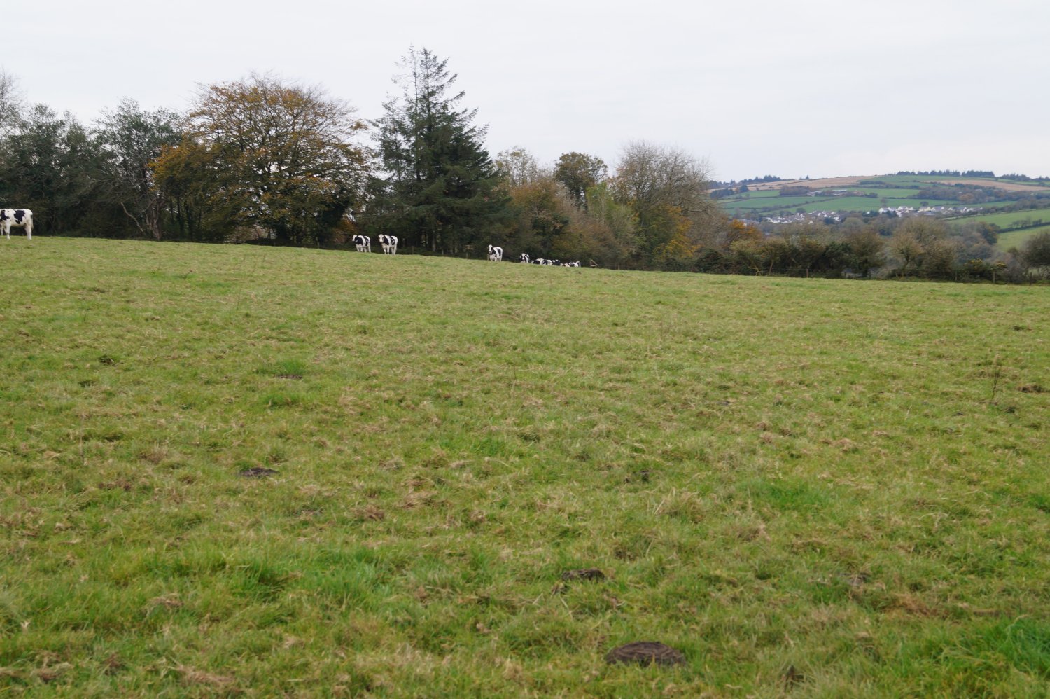
Disgrifiad: Mae’r tir wedi ei osod allan mewn patrwm siap “ L ”, ac yn cynnwys nifer o gaeau sylweddol eu maint, ar oleddf ysgafn, ac mae’r pedwar cae gwaelod wedi eu rhannu oddi wrth y pedwar arall gan glawdd terfyn wedi ei ffensio ar gyfer cadw defaid.
Mae pedwar cae’r bloc gwaelod ar oleddf ysgafn, a rhan ogleddol y caeau yn fwy serth. Mae’r caeau yn cael eu trafod fel un bloc, a ffens sylfaenol ar gyfer gwartheg yn unig yw rhan helaethaf y ffin. Ceir ardal fechan goediog ar hyd y ffin ogleddol.
Mae’r bloc uchaf wedi ei ffensio ar gyfer defaid yn bennaf, a’r rhannau coediog wedi eu ffensio ar hyd yr ochrau gorllewinol. Mae’r parsel mwy gwastad hwn wedi ei rannu yn bedwar cae, ac eto yn cael eu trafod fel un bloc, ac yn goleddfu’n raddol i lawr tua’r ffin orllewinol. Mae’r ddau gyflenwad dŵr preifat wedi eu lleoli yn y bloc yma, ac yn rhedeg drwy ddisgyrchiant mewn pibell i’r bloc gwaelod.
Iacs: Cofrestrwyd y tir yn flaenorol i’r diben hwn. Darpar brynwyr i fodloni eu hunain o ran cofrestru’r tir yn y dyfodol. Nid oes Unedau Cynllun Taliad Sylfaenol ar gael gyda’r eiddo.
Hawliau tramwyo
Mae’r eiddo yn cael ei werthu ynghyd â budd pob hawl, gan gynnwys hawliau tramwyo, naill ai’n gyhoeddus neu’n breifat, cynhorthwy golau, draenio a dŵr a chyflenwadau trydan, ac unrhyw hawliau eraill, hawddfreinitau, lled-hawddfreintiau a chyfamodau caethiwus, pob hawliau gosod presennol a dyfodol o ran mastiau, polion, ceblau, draenio a dŵr, nwy a phibellau eraill, pa un ai a gyfeirir atynt yn y manylion hyn ai peidio.
1. O edrych ar y cynllun arolwg ordnans lleol, nodwn fod yna lwybr cyhoeddus yn croesi rhan ogleddol y bloc gwaelod, o’r dwyrain i’r gorllewin, ond ni wyddom a yw’r llwybr hwn yn cael ei ddefnyddio ai peidio.
2. Mae yna hawl gofnodedig i berchnogion y bloc tir cyffiniol dynnu dŵr o’r siambr ddŵr breifat ym mharsel rhif 7242, i’w parsel nhw, rhif 7615. Rydym hefyd yn deall fod pibell gyflenwad o’r siambr yn disgyn drwy glos Fferm y Glôg i danc yn y bloc gwaelod.
3. Mae hawl tramwyo ar hyd y feidr garreg sy’n ffinio â pharsel 7242 gan berchnogion y tir er mwyn cynnal a chadw clawdd y cae sy’n ffinio â’r feidr, ac i gael mynediad o’r cae drwy’r iet, ar hyd y feidr ac allan i’r ffordd wledig.
Rhestr erwau: Ar gael ar ofyniad.
-------------------------------------------------------------------------------------------------------------------------------------
A 69 acre block of improvable land, with some 63 acres classed as pasture and balance of wood/scrub, set overlooking the rural community of Glogue, with private water supply and divided into two sections, with roadside access at two points and suited for farmers/investors and known as
land formerly part of glogue farm, glogue, llanfyrnach, pembrokeshire, SA36 0ED
Situation: Grid Ref. SN215-330
The land is accessed off a minor road, climbing up from the rural village of Glogue ( ¼ mile) towards the village of Tegryn (1 mile). Tegryn provides for primary school, community centre and public house. The market village of Crymych is some 2 ¾ miles distant, which has primary and secondary education, various retail facilities, public house, doctor’s surgery and regular sheep market. The market towns of Cardigan and Newcastle Emlyn are some 11 miles equidistant and have an array of facilities.
Services: Private water supply via original well and later borehole. Prospective purchasers to make their own enquiries about availability of mains water and electric connections in the vicinity.
Viewing: At any convenient time with a set of these particulars. Please do not take vehicles onto the land.
Directions: From the A478 in Crymych, take the turning for Hermon/Llanfyrnach by Ysgol y Preseli. Carry on into Hermon to the ‘give way’ and turn left. As you leave Hermon bear left for Glogue by the Chapel and then turn left for Glogue a short distance onwards. Go down into the village, cross the bridge and start climbing up the hill. The two gateways where the land is accessed are located on the left hand side, one just before the entrance to the quarry and the other further up the hill on the entrance of a hardcore track, also giving access to neighbouring land. Our “For Sale” boards will be erected on site.
Description: The land is laid out in a ‘L’ shaped pattern and consists of sizable, mainly gently sloping enclosures, with the bottom 4 fields divided away from the top block by a sheep proof, fenced hedgerow.
The bottom block is gently sloping as a whole, with the northern aspects of the four fields being more sloping. The fields are run as one block and the vast majority of the boundary is only a basic fence for cattle. A small wooded area lies on the northern boundary.
The top block is mainly fenced for sheep, with the wooded areas fenced away on the western aspects. This more level parcel is divided into 4 fields and again is run as one block, and gently slopes down towards the Western boundary. The two private water supply sources are located on this block and are gravity fed down to the bottom block.
Iacs: The land has previously been registered for this purpose. Prospective purchasers to satisfy themselves for future registration purposes. No bps units available.
Rights of Way:
The property is sold with the benefit of all rights including rights of way, whether public or private, light support, drainage and water and electricity supplies and other rights, easements, quasieasements and restrictive covenants, all existing and proposed way leaves for masts, pylons, stays, cables, drain and water, gas and other pipes, whether referred to in these particulars or not.
1. From the local ordnance survey plan, we note that a public footpath crosses the northern aspect of the bottom block from east to west, but we cannot comment on whether it is used.
2. There is a documented right for the owners of a bounding block of land to draw water from the private supply chamber in parcel no 7242 and into parcel no 7615. We also understand that the supply pipe from the chamber runs down through the Glogue Farm Homestead to the bottom block.
3. A right of way along the track bounding with parcel no 7242 to maintain the length of hedgerow bounding with the track and to access the gateway from the field along the track out to the district road.
Schedule of Acreage - Available on request.
Disclaimer
All properties are offered for sale subject to contract and availability.
We endeavour to make our sales details accurate and reliable but they should not be relied on as statements or representations of fact and they do not constitute any part of an offer or contract. The seller does not make any representation or give any warranty in relation to the property and we have no authority to do so on behalf of the seller.
Services, fittings and equipment referred to in the sales details have not been tested (unless otherwise stated) and no warranty can be given as to their condition.
We would strongly recommend that all the information which we provide about the property is verified by yourself or your advisers.
Please contact us before viewing the property. If there is any point of particular importance to you we will be pleased to provide additional information or to make further enquiries. We will also confirm that the property remains available. This is particularly important if you are contemplating travelling some distance to view the property.
tir oedd yn flaenorol yn rhan O fferm Y glôg, Y glôg, llanfyrnach, sir benfro, SA36 0ED
lleoliad: Cyfeirnod Grid: SN215-330
Ceir mynediad i’r tir oddi ar ffordd wledig, yn esgyn o bentref Y Glôg ( 0.25 milltir ) tuag at bentref Tegryn ( 1 milltir ) lle ceir ysgol gynradd, canolfan gymunedol a thafarn. Mae pentref marchnad Crymych ryw 2 ¾ milltir i ffwrdd, ac mae yno ysgol uwchradd, canolfan hamdden, amryfal siopau, meddygfa, tafarn, a marchnad ddefaid reolaidd. Mae trefi marchnad Castell Newydd Emlyn ac Aberteifi fel ei gilydd ryw 11 milltir i ffwrdd, a cheir ynddynt amrediad o gyfleustodau.
Daliadaeth: Rydym wedi cael ar ddeall fod yr eiddo yn Rhydd-ddaliad.
Gwasanaethau: Cyflenwad dŵr preifat ar y tir a thrydylldwll (borehole) yn ddiweddarach. Darpar brynwyr i wneud eu ymholiadau eu hunain er mwyn darganfod pa gysylltiadau prif gyflenwadau dŵr a thrydan sydd ar gael yn y cyffiniau, os ydynt yn dymuno.
Trefn gweld Y tir: Ar unrhyw adeg gyfleus, gyda chopi o’r manylion yma. Peidiwch os gwelwch yn dda â mynd â cherbydau ar y tir.
Cyfarwyddiadau: O ffordd yr A478 yng Nghrymych, trowch am Hermon / Llanfyrnach ger Ysgol y Preseli. Ewch ymlaen i Hermon, ac ar y gyffordd, trowch i’r chwith. Fel y byddwch yn gadael y pentref ger y Capel, cadwch i’r chwith am y Glôg, ac yn fuan wedyn, trowch lawr i’r chwith unwaith eto. Ewch lawr i’r pentref, dros y bont, a dechrau dringo i fyny’r rhiw. Mae’r ddwy fynedfa i’r tir ar y chwith – un cyn mynedfa Cware’r Glôg, a’r llall ymhellach i fyny wrth y fynedfa i feidr garreg, sydd hefyd yn darparu mynediad i dir cyffiniol. Fe fydd ein harwyddion “Ar Werth” wedi eu gosod gerllaw’r ddwy fynedfa.
Disgrifiad: Mae’r tir wedi ei osod allan mewn patrwm siap “ L ”, ac yn cynnwys nifer o gaeau sylweddol eu maint, ar oleddf ysgafn, ac mae’r pedwar cae gwaelod wedi eu rhannu oddi wrth y pedwar arall gan glawdd terfyn wedi ei ffensio ar gyfer cadw defaid.
Mae pedwar cae’r bloc gwaelod ar oleddf ysgafn, a rhan ogleddol y caeau yn fwy serth. Mae’r caeau yn cael eu trafod fel un bloc, a ffens sylfaenol ar gyfer gwartheg yn unig yw rhan helaethaf y ffin. Ceir ardal fechan goediog ar hyd y ffin ogleddol.
Mae’r bloc uchaf wedi ei ffensio ar gyfer defaid yn bennaf, a’r rhannau coediog wedi eu ffensio ar hyd yr ochrau gorllewinol. Mae’r parsel mwy gwastad hwn wedi ei rannu yn bedwar cae, ac eto yn cael eu trafod fel un bloc, ac yn goleddfu’n raddol i lawr tua’r ffin orllewinol. Mae’r ddau gyflenwad dŵr preifat wedi eu lleoli yn y bloc yma, ac yn rhedeg drwy ddisgyrchiant mewn pibell i’r bloc gwaelod.
Iacs: Cofrestrwyd y tir yn flaenorol i’r diben hwn. Darpar brynwyr i fodloni eu hunain o ran cofrestru’r tir yn y dyfodol. Nid oes Unedau Cynllun Taliad Sylfaenol ar gael gyda’r eiddo.
Hawliau tramwyo
Mae’r eiddo yn cael ei werthu ynghyd â budd pob hawl, gan gynnwys hawliau tramwyo, naill ai’n gyhoeddus neu’n breifat, cynhorthwy golau, draenio a dŵr a chyflenwadau trydan, ac unrhyw hawliau eraill, hawddfreinitau, lled-hawddfreintiau a chyfamodau caethiwus, pob hawliau gosod presennol a dyfodol o ran mastiau, polion, ceblau, draenio a dŵr, nwy a phibellau eraill, pa un ai a gyfeirir atynt yn y manylion hyn ai peidio.
1. O edrych ar y cynllun arolwg ordnans lleol, nodwn fod yna lwybr cyhoeddus yn croesi rhan ogleddol y bloc gwaelod, o’r dwyrain i’r gorllewin, ond ni wyddom a yw’r llwybr hwn yn cael ei ddefnyddio ai peidio.
2. Mae yna hawl gofnodedig i berchnogion y bloc tir cyffiniol dynnu dŵr o’r siambr ddŵr breifat ym mharsel rhif 7242, i’w parsel nhw, rhif 7615. Rydym hefyd yn deall fod pibell gyflenwad o’r siambr yn disgyn drwy glos Fferm y Glôg i danc yn y bloc gwaelod.
3. Mae hawl tramwyo ar hyd y feidr garreg sy’n ffinio â pharsel 7242 gan berchnogion y tir er mwyn cynnal a chadw clawdd y cae sy’n ffinio â’r feidr, ac i gael mynediad o’r cae drwy’r iet, ar hyd y feidr ac allan i’r ffordd wledig.
Rhestr erwau: Ar gael ar ofyniad.
-------------------------------------------------------------------------------------------------------------------------------------
A 69 acre block of improvable land, with some 63 acres classed as pasture and balance of wood/scrub, set overlooking the rural community of Glogue, with private water supply and divided into two sections, with roadside access at two points and suited for farmers/investors and known as
land formerly part of glogue farm, glogue, llanfyrnach, pembrokeshire, SA36 0ED
Situation: Grid Ref. SN215-330
The land is accessed off a minor road, climbing up from the rural village of Glogue ( ¼ mile) towards the village of Tegryn (1 mile). Tegryn provides for primary school, community centre and public house. The market village of Crymych is some 2 ¾ miles distant, which has primary and secondary education, various retail facilities, public house, doctor’s surgery and regular sheep market. The market towns of Cardigan and Newcastle Emlyn are some 11 miles equidistant and have an array of facilities.
Services: Private water supply via original well and later borehole. Prospective purchasers to make their own enquiries about availability of mains water and electric connections in the vicinity.
Viewing: At any convenient time with a set of these particulars. Please do not take vehicles onto the land.
Directions: From the A478 in Crymych, take the turning for Hermon/Llanfyrnach by Ysgol y Preseli. Carry on into Hermon to the ‘give way’ and turn left. As you leave Hermon bear left for Glogue by the Chapel and then turn left for Glogue a short distance onwards. Go down into the village, cross the bridge and start climbing up the hill. The two gateways where the land is accessed are located on the left hand side, one just before the entrance to the quarry and the other further up the hill on the entrance of a hardcore track, also giving access to neighbouring land. Our “For Sale” boards will be erected on site.
Description: The land is laid out in a ‘L’ shaped pattern and consists of sizable, mainly gently sloping enclosures, with the bottom 4 fields divided away from the top block by a sheep proof, fenced hedgerow.
The bottom block is gently sloping as a whole, with the northern aspects of the four fields being more sloping. The fields are run as one block and the vast majority of the boundary is only a basic fence for cattle. A small wooded area lies on the northern boundary.
The top block is mainly fenced for sheep, with the wooded areas fenced away on the western aspects. This more level parcel is divided into 4 fields and again is run as one block, and gently slopes down towards the Western boundary. The two private water supply sources are located on this block and are gravity fed down to the bottom block.
Iacs: The land has previously been registered for this purpose. Prospective purchasers to satisfy themselves for future registration purposes. No bps units available.
Rights of Way:
The property is sold with the benefit of all rights including rights of way, whether public or private, light support, drainage and water and electricity supplies and other rights, easements, quasieasements and restrictive covenants, all existing and proposed way leaves for masts, pylons, stays, cables, drain and water, gas and other pipes, whether referred to in these particulars or not.
1. From the local ordnance survey plan, we note that a public footpath crosses the northern aspect of the bottom block from east to west, but we cannot comment on whether it is used.
2. There is a documented right for the owners of a bounding block of land to draw water from the private supply chamber in parcel no 7242 and into parcel no 7615. We also understand that the supply pipe from the chamber runs down through the Glogue Farm Homestead to the bottom block.
3. A right of way along the track bounding with parcel no 7242 to maintain the length of hedgerow bounding with the track and to access the gateway from the field along the track out to the district road.
Schedule of Acreage - Available on request.
Disclaimer
All properties are offered for sale subject to contract and availability.
We endeavour to make our sales details accurate and reliable but they should not be relied on as statements or representations of fact and they do not constitute any part of an offer or contract. The seller does not make any representation or give any warranty in relation to the property and we have no authority to do so on behalf of the seller.
Services, fittings and equipment referred to in the sales details have not been tested (unless otherwise stated) and no warranty can be given as to their condition.
We would strongly recommend that all the information which we provide about the property is verified by yourself or your advisers.
Please contact us before viewing the property. If there is any point of particular importance to you we will be pleased to provide additional information or to make further enquiries. We will also confirm that the property remains available. This is particularly important if you are contemplating travelling some distance to view the property.