Land For Sale £550,000
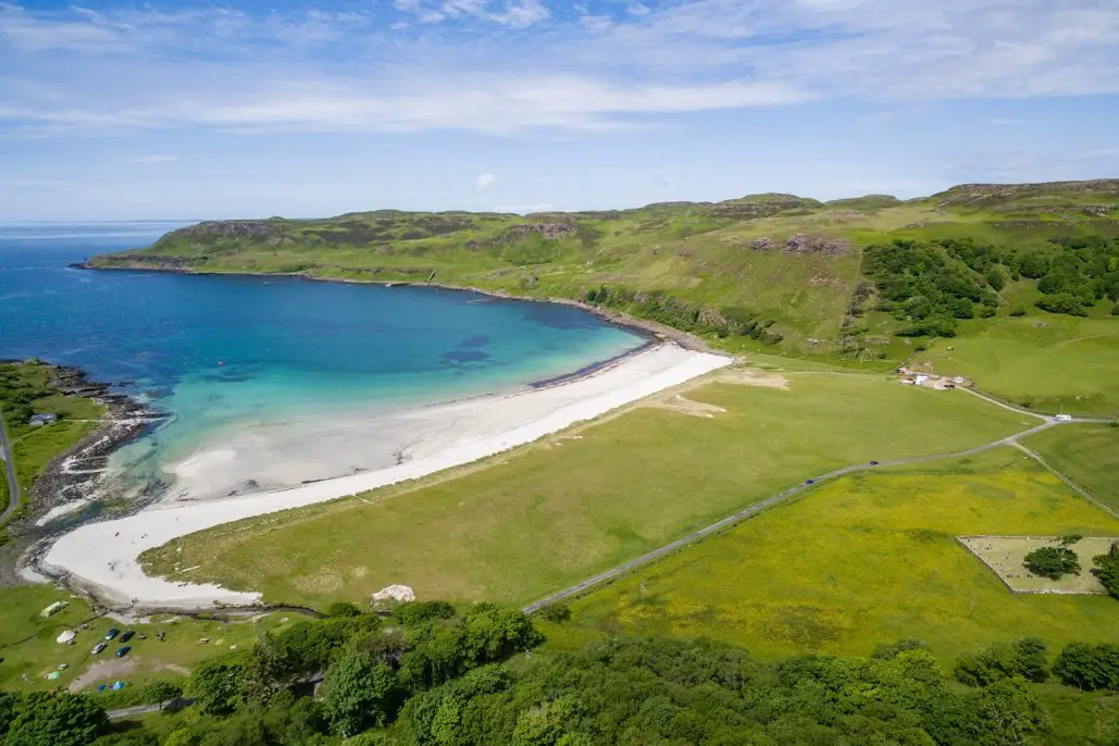
The land at Calgary Bay lies on the north side of the bay and is accessed over a private track leading from the public car park at Calgary Bay through a locked gate. The land comprises a spectacular block of land with sweeping views to the Treshnish Isles, Coll, and the Small Isles, as well as dramatic views back over Mull beyond the famous beach at Calgary.
The land is a mixture of pasture land and hill grazing being graded a combination of 6.2 and 6.3 by the James Hutton Institute’s land capability for agriculture maps. The subjects have a southerly aspect and range in height from sea level to 166 metres. The land is currently grazed by sheep on a seasonal basis. Please note there are no Basic Payment Entitlements owned or included in the sale.
Approximately 900m from the public car park is Calgary Pier. The pier is c-listed by Historic Environment Scotland. It is understood that the pier was built to enable boats to deliver coal to the Mornish Estate. It was also used to ferry sheep to and from grazings on the Treshnish Isles. Just behind the pier are the remains of a boathouse as well as other former structures further up the hillside. Some of these former buildings/sites may have potential or provide the basis for future development subject to obtaining appropriate planning consents.
There is no electricity or mains water supply to the land at Calgary Bay.<br /><br />Calgary Bay is located at the northwest tip of the
Isle of Mull, approximately 5 miles from the village of Dervaig and 12 miles from the principal town of Tobermory. The winding B8073 coastal road leads from Tobermory through beautiful countryside before dropping down through the village of Dervaig to the hamlet of Calgary and onto the bay itself.
Calgary beach is picture perfect with white sands and blue seas. It is known to be one of Scotland’s finest beaches, backed by low dunes and fertile low lying pastures.
On the north side of the Bay, where the property is located, there is a footpath to the old pier. The
path continues steeply to the ruined township of Inivea, which comprises in excess of 20 ruins dating back to the 18th or early 19th century.
Further exploration along the coastal track leads
to another abandoned community, the ruined
houses of Arin, where stunning views across the
Tiree Passage can be enjoyed.
On the south side of Calgary Bay, the single track road winds its way round the coast passing Treshnish, Torloisk, the Eas Fos Waterfall and
reaching the small ferry landing for the short
crossing to Ulva.
The main settlement on the Isle of Mull is Tobermory (12 miles) which provides a wide range of retail, leisure and commercial facilities. The population is currently around 1,000 and the town is home to the only secondary school on the island.
Glasgow is the nearest city and lies approximately 97 miles to the southeast from the ferry terminal in Oban. Glasgow has a full range of retail, educational, leisure and commerce facilities, together with mainline railway stations and an international airport with flights to a wide range of UK and overseas destinations.<br /><br />Historical Note
The name comes from the Gaelic, Cala ghearraidh, meaning Beach of the meadow (pasture). “Cala” is the word specifically used for a hard, sandy beach suitable for landing a boat. However, the museum on the Isle of Mull explains that kald and gart are similar Old Norse words, meaning “cold” and “garden”, that the Vikings used when they inhabited the island.
Just up the hill from the pier is the deserted village of Inivea, where roofless stone ruins remain as a relic of the Highland clearances. It is understood that many families affected by the clearances left for Canada from the pier at Calgary Bay.
At Inivea, over 20 buildings of the township can be seen, several of them still standing to wall head level. These include houses and barns, with enclosures thought to be areas once used as kitchen-gardens.
Above the houses, a relatively flat area to the north presents patterns suggesting ridge and furrow cultivation, and the supposed site of a drying kiln. A rocky knoll above sites the remains of a medieval fort, though many of its stones were taken to build the houses.
On the east side of the bay is Calgary Castle, once a Laird’s house (Calgary House) which, in 1817, was extended by Alan MacAskill. Colonel James Macleod, Commissioner of the North-West Mounted Police, was a summer guest here. In 1876, shortly after returning to Canada, he suggested its name for Fort Calgary, a settlement there, which today is the metropolitan city of Calgary, Alberta, with a population of 1,200,000 residents.