House For Rent £775
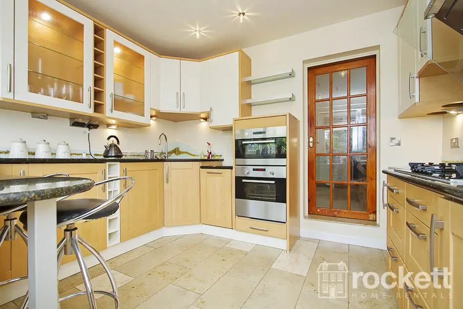
Amazing 2 bed cottage. This property has been refurbished to a very high standard. This property resides in the picturesque village of Madeley. It comprises a modern living room, dining room, state of the art fitted kitchen with limestone tiled underfloor heating, integrated appliances including dishwasher, five ring gas hob with ultra modern cooker hood. On the first floor are two double bedrooms and a bathroom with tower shower cabin with body jets. There is a loft storage conversion with converted staircase. Off road parking. P2287
Full Description
No tenant application fees. Amazing 2 bed cottage. This property has been refurbished to a very high standard. This property resides in the picturesque village of Madeley. It comprises a modern living room, dining room, state of the art fitted kitchen with limestone tiled underfloor heating, integrated appliances including dishwasher, five ring gas hob with ultra modern cooker hood. On the first floor are two double bedrooms and a bathroom with tower shower cabin with body jets. There is a loft storage conversion with converted staircase. There is off road parking.
Madeley is a village just inside Staffordshire, between Crewe and Newcastle-under-Lyme, and is on the border between Staffordshire and Cheshire (and close to the Shropshire border too!) It is closest to Newcastle-under-Lyme, and is within the Staffordshire council area and with Stoke-on-Trent area codes (01782), yet it has Crewe (CW3) postcodes!
It is split into three parts: Madeley, Middle Madeley, and Little Madeley. Madeley Heath is also considered by many to be part of Madeley. In the 2001 census, the population was recorded as 4,386.
Madeley is located 5 miles (8.0 km) west of Newcastle-under-Lyme town centre and is close to the Shropshire and Cheshire borders. To the north are the villages of Betley and Wrinehill. South is the hamlet of Baldwin`s Gate. To the east is Keele, the site of Keele University as well as Silverdale, whilst to the west lies Onneley and Woore.
Madeley is derived from the Saxon, Madanlieg, meaning `a clearing in the woods belonging to Mada` (Mada is a female Saxon name).
Madeley is recorded in the Domesday Book as being 2,160 acres (8.7 km2) of wood and 4 plough teams. The first Madeley Old Manor was built by Robert de Stafford, with the local church being founded in 1200. Heighley Castle was built in 1226 by Henry de Audley and ordered to be demolished by Parliamentary committee sitting at Stafford in 1644 to prevent its use by Royalists. Little remains today but some of the ruins are still visible during winter through the vegetation surrounding the area. There is also Madeley Old Hall.
A significant feature and well known landmark of the village is Madeley Mill standing on the dam for the pool. During its history the mill was used for grinding grain but prior to its closure, production was turned over to cheese making. It fell into disrepair before being developed and converted into apartments in the early 1990s saving it from proposed demolition by the local council.
North Staffordshire was a centre for coal mining and the nearby mine at Leycett was known as Madeley under the National Coal Board.Sinking began in the 1880s and the Colliery had five shafts with exotic names: Bang Up, Fair Lady, Clarkes, Harrisons and Woodburn.The Pit closed on 21 September 1957. There is nothing left of the site nowadays and it is used for agriculture.
Madeley has three schools. Two primary schools, Meadows and Sir John Offley Primary School. The Madeley high school secondary school serves the surrounding area.
As part of the expansion in higher and further education, Madeley College opened in 1962 and specialised in Men`s Physical Education and Home Economics. It closed in the mid-1980s after becoming part of the North Staffordshire Polytechnic
The majority of the settlement sits between the M6 motorway and the West Coast Main Line but there is no access to the motorway or a railway station. The A525 road passes through Madeley as a primary route. It connects with the A531 which further connects with the A500 to the north.
In World War II when food was rationed, a lorry overturned on the A351 road which was carrying Stork margarine. People came from miles around came to recover the contents, resulting in its naming as Margarine Corner, which continues today.
Council tax band C
to rent A property through Rockett Home Rentals, you would need to be able to pass A professional credit and reference check. P2287