Land For Sale £800,000
LOCATION
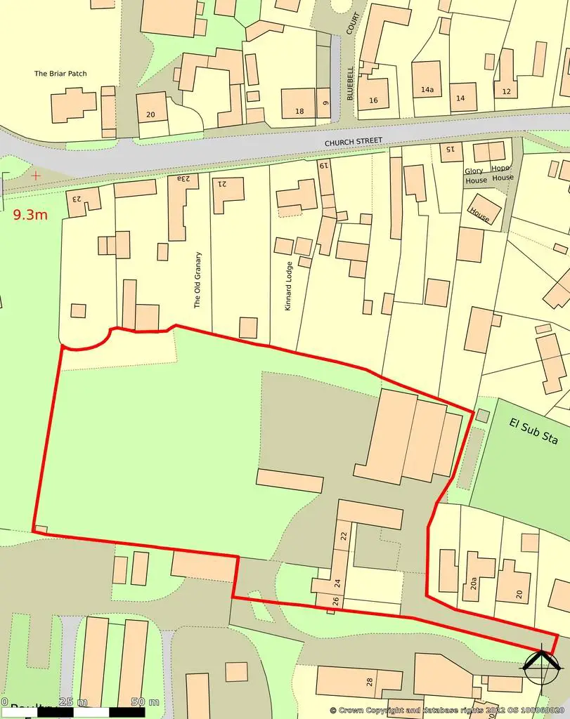
The site is situated on the edge of the trent side village of Owston Ferry, lying immediately to the north of the impressive Hall.
The village presently delivers several local amenities with ready road access to other larger settlements including Misterton, Epworth, Isle of Axholme generally and Doncaster beyond. The A161 lies to the west providing access to the M180 to the north and wider motorway network beyond.
DIRECTIONS
Travelling north on the A161 from Misterton direction, at Graizelound turn right signposted Owston Ferry. Proceed along and when entering the village on Station Road, at the right hand bend bear left on the lane to find the site at the end.
DESCRIPTION
A mixed residential development site with a variety of planning permissions both full and outline for a total of five new build dwellings together with listed barn for conversion and four listed derelict cottages in need of complete modernisation. The three plots with details consents each provide a three bedroom detached house. The site includes an area of undeveloped, unconsented land which lies adjacent to a neighbouring Scheduled Monument – Motte and Bailey Castle.
PLANNING
North Lincolnshire Council has granted the following planning permissions:-
• Application no. PA/2021/1290 dated 14 January 2022 – outline planning permission to erect two dwellings (including demolition of existing buildings) with all matters reserved for subsequent consideration.
• Application no. PA/2020/1345 dated 26 March 2021 – planning permission to convert existing barn to residential and erect two detached dwellings with associated works.
• Application no. PA/2022/542 dated 7 July 2022 – full planning permission to erect a detached dwelling and garage (Plot 3) with associated works.
Copies of decision notices, approved drawings and supporting documents may be viewed on the council's planning portal apps.northlincs.gov.uk searching the above reference numbers.
All enquiries relating to planning and listing matters should be addressed to North Lincolnshire council.
LISTING
The barn is Grade II Listed – list entry number 1346712. The derelict cottages, no's. 24 and 26 and range adjoining to north are Grade II Listed – list entry number 1049046.
COMMUNITY INFRASTRUCTUVE LEVY (CIL)
In the event North Lincolnshire Council decide to adopt Community Infrastructure Levy, any CIL payments arising therefrom will be borne by the buyer.
PLANS
Plans within these particulars are strictly for identification purposes only and will form no part of any contract or agreement for sale. The plans accompanying the planning applications are available on North Lincolnshire Council's website as above.
TENURE
The site is understood to be freehold.
EASEMENTS, WAYLEAVES AND RIGHTS OF WAY
The property is sold subject to, and with the benefit of, all rights of way whether public or private, light, support, drainage, water and electricity and all other rights and obligations, easements, quasi easements, quasi rights, licences, privileges and restrictive covenants and all existing and proposed wayleaves for electricity, drainage, water and other pipes whether referred to in these particulars or not.
SERVICES
Whilst some services are understood to be available on site and in the locality, purchasers are expressly requested to make their own enquiries as to the location, nature, specification, capacity and cost of connection.
VIEWING
Strictly by appointment only. Please contact the selling agents.
FURTHER INFORMATION
Please contact Jeremy Baguley MRICS. [use Contact Agent Button] or
[use Contact Agent Button]