Land For Sale £210,000
A modern agricultural / storage building with three nearby pasture fields in a fine setting. 5.44 acres (2.21 hectares). Views towards the Blackdown and Quantock Hills. Building used for mixed storage with direct road access. Pasture land for mowing and grazing. For sale by private treaty. FREEHOLD.
Situation - The land and barn are located just outside the northern boundary of the Blackdown Hills Area of Outstanding Natural Beauty (AONB), approximately 2 miles to the south-east of West Buckland in Somerset and 4.5 miles to the south-east of Wellington.
The Somerset County Town of Taunton lies 5 miles north-west of the property and Junction 26 of the M5 is within 2.5 miles.
Description - The land and barn are surrounded by open countryside with fine views up to the Blackdown Hills and over the Taunton Vale towards the Quantock Hills. The property extends to 5.44 acres (2.21 hectares) and is offered for sale as a whole or in two lots.
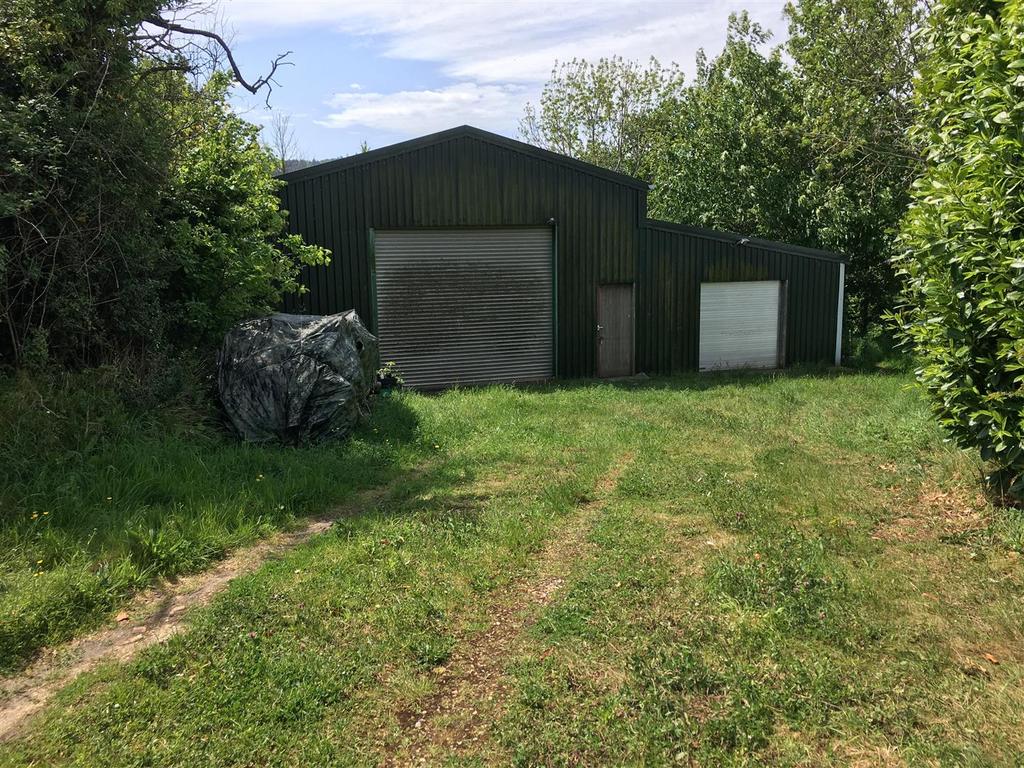
The Building - The building sits in a plot of 0.21 acres (0.09 hectares) and measures approximately 13.47m x 7.49m with a Lean-to measuring 13.47m x 4.43m. It is constructed with a steel frame, fully enclosed with box profile steel sheets and a concrete floor. In the main section of the building there is a mezzanine level.
The building is approached from the road through timber gate and has an open area of grass to the front and a small area surrounding the building on the southern and western sides. From the front of the building there are views over the Taunton Vale.
The Land - The land comprises three grass fields which total 5.23 acres (2.12 hectares) which adjoin a stream on the western boundary and have views towards the Blackdown and Quantock Hills.
The field nearest the road is sloping with a gate opening into a larger gently sloping enclosure and the third level enclosure nearest the stream. Both of the lower fields are suitable for mowing and the mature boundary trees create a park like setting.
Access - There is direct access from a council road to both lots.
Services - There is a mains water connection to the land, which also has access to a stream. There are no mains services connected to the building.
Method Of Sale - The land and building are offered for sale by private treaty.
Tenure - The property is owned freehold and is registered on the Land Registry. Vacant possession is available from the completion date.
Basic Payment Scheme (Bps) - There are no entitlements to be transferred with the land.
Overage - The farm building will be sold subject to a development uplift (overage) provision on the following terms: Upon planning consent being granted for any residential use within a 30 year period from the completion date, the sellers will receive 25% of the increase in value (assessed by an independent valuer).
Designations - The land is not within a Nitrate Vulnerable Zone (NVZ).
Planning - Planning consent for the building was originally approved on 30th August 1996 for a mixed agricultural / storage use (reference 30 / 96 / 016).
Local Authority - Somerset West & Taunton Council:
Wayleaves & Rights Of Way - The property is sold subject to and with the benefit of any wayleave agreement and any public or private rights of way that may affect it.
There is a public footpath crossing the land.
Sporting And Mineral Rights - The sporting and mineral rights insofar as they are owned are included with the freehold.
Land Plan - A plan which is not to scale, is included with these sale particulars for identification purposes only.
Viewing - Viewing is strictly by prior appointment. Please contact Stags[use Contact Agent Button] or [use Contact Agent Button]) to arrange an appointment.
Please note that first viewings for the barn will be externally only.
Directions - From Junction 26 of the M5, follow directions to West Buckland. Upon reaching the T-junction in the village, turn right and continue through the village. Just before the bridge over the M5, turn right into Stoford Lane signed towards Trull.
At the next junction follow the road around to the right, signed towards Trull and Taunton. Continue for approximately 700 yards to Cutsey and follow the road around to the right, continue underneath the M5 and Travel on towards Cutsey and cross the bridge over the M5. Continue along this road for 0.6 miles and the building will be found on the right. Continue for a further 100 yards and the land will be found on the right.
Disclaimer - These particulars are a guide only and are not to be relied upon for any purpose.
Situation - The land and barn are located just outside the northern boundary of the Blackdown Hills Area of Outstanding Natural Beauty (AONB), approximately 2 miles to the south-east of West Buckland in Somerset and 4.5 miles to the south-east of Wellington.
The Somerset County Town of Taunton lies 5 miles north-west of the property and Junction 26 of the M5 is within 2.5 miles.
Description - The land and barn are surrounded by open countryside with fine views up to the Blackdown Hills and over the Taunton Vale towards the Quantock Hills. The property extends to 5.44 acres (2.21 hectares) and is offered for sale as a whole or in two lots.
The Building - The building sits in a plot of 0.21 acres (0.09 hectares) and measures approximately 13.47m x 7.49m with a Lean-to measuring 13.47m x 4.43m. It is constructed with a steel frame, fully enclosed with box profile steel sheets and a concrete floor. In the main section of the building there is a mezzanine level.
The building is approached from the road through timber gate and has an open area of grass to the front and a small area surrounding the building on the southern and western sides. From the front of the building there are views over the Taunton Vale.
The Land - The land comprises three grass fields which total 5.23 acres (2.12 hectares) which adjoin a stream on the western boundary and have views towards the Blackdown and Quantock Hills.
The field nearest the road is sloping with a gate opening into a larger gently sloping enclosure and the third level enclosure nearest the stream. Both of the lower fields are suitable for mowing and the mature boundary trees create a park like setting.
Access - There is direct access from a council road to both lots.
Services - There is a mains water connection to the land, which also has access to a stream. There are no mains services connected to the building.
Method Of Sale - The land and building are offered for sale by private treaty.
Tenure - The property is owned freehold and is registered on the Land Registry. Vacant possession is available from the completion date.
Basic Payment Scheme (Bps) - There are no entitlements to be transferred with the land.
Overage - The farm building will be sold subject to a development uplift (overage) provision on the following terms: Upon planning consent being granted for any residential use within a 30 year period from the completion date, the sellers will receive 25% of the increase in value (assessed by an independent valuer).
Designations - The land is not within a Nitrate Vulnerable Zone (NVZ).
Planning - Planning consent for the building was originally approved on 30th August 1996 for a mixed agricultural / storage use (reference 30 / 96 / 016).
Local Authority - Somerset West & Taunton Council:
Wayleaves & Rights Of Way - The property is sold subject to and with the benefit of any wayleave agreement and any public or private rights of way that may affect it.
There is a public footpath crossing the land.
Sporting And Mineral Rights - The sporting and mineral rights insofar as they are owned are included with the freehold.
Land Plan - A plan which is not to scale, is included with these sale particulars for identification purposes only.
Viewing - Viewing is strictly by prior appointment. Please contact Stags[use Contact Agent Button] or [use Contact Agent Button]) to arrange an appointment.
Please note that first viewings for the barn will be externally only.
Directions - From Junction 26 of the M5, follow directions to West Buckland. Upon reaching the T-junction in the village, turn right and continue through the village. Just before the bridge over the M5, turn right into Stoford Lane signed towards Trull.
At the next junction follow the road around to the right, signed towards Trull and Taunton. Continue for approximately 700 yards to Cutsey and follow the road around to the right, continue underneath the M5 and Travel on towards Cutsey and cross the bridge over the M5. Continue along this road for 0.6 miles and the building will be found on the right. Continue for a further 100 yards and the land will be found on the right.
Disclaimer - These particulars are a guide only and are not to be relied upon for any purpose.