Land For Sale £750,000
A block of mixed use land situated adjacent to the River Tyne between the Northumbrian villages of Wylam and Crawcrook.
Situation
Lying to the South of the River Tyne, the Land off Crawcrook Lane is situated between the villages of Wylam and Crawcrook, approximately 9.4 miles West of Newcastle upon Tyne.
The land straddles either side of the Newcastle and Carlisle Railway Line, with the majority of the land lying to the South of the railway and accessed from Crawcrook Lane. The land to the North of the railway forms the river bank to the River Tyne and is accessed on foot along Keelman’s Way Byway.
The A69 is 3.7 miles to the North and the A1 is 5.8 miles to the East, providing good accessibility to the length and breadth of the country.
Description
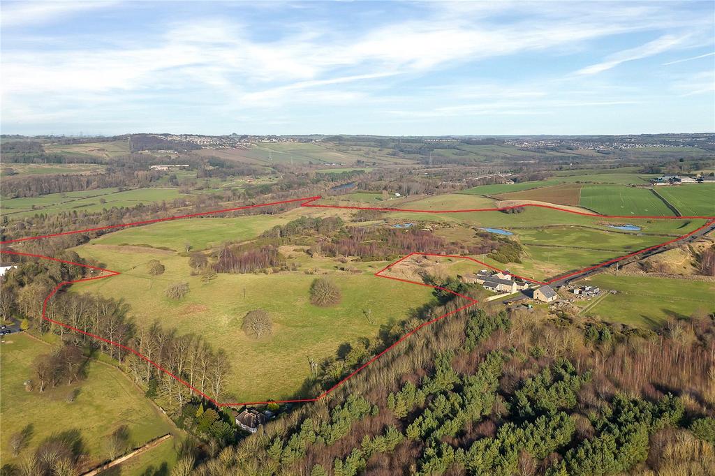
The Property extends as whole to approximately 107.33 acres (43.42 hectares) with a block of 99.70 acres (40.34 hectares) lying to the South of the railway line and the remaining land to the North.
The southern block includes the former sand and gravel quarry, which ceased operations in 2012. The block comprises of about 66.31 acres (26.83 hectares) of grassland, 29.75 acres (12.03 hectares) of natural regeneration, partially restored, 5.27 acres (2.13 hectares) of woodland, with the remainder made up internal tracks.
The land to the North of the railway line extends to about 7.63 acres (3.08 hectares) and is made up primarily of woodland. The purchaser will benefit from the fishing rights along this stretch of the River Tyne which are included in the sale.
Classified as Grade 3, the soil in the non-quarried areas are identified as being ‘freely draining slight acid sand soils’.
Method of Sale
Available as a whole by Private Treaty.
Tenure & Tenancies
The Freehold (Registered Title Number: TY377689 and TY343388), interest in the Property is being offered for sale subject to a Farm Business Tenancy expiring on 31 March 2024.
The fishing rights are included within the sale and currently subject to a 12 month fishing licence.
The Vendor is prepared to serve a Notice to Quit on the Tenancies to provide vacant possession upon completion.
Services
Prospective purchasers must satisfy themselves as to the availability of services and any future connections.
Basic Payment Scheme & Environmental Stewardship
The Property is offered for sale without the benefit of Basic Payment Scheme entitlements.
The Property was previously included within an agri-environment scheme, although we understand such agreement has now ended.
Wayleaves, Easements & Rights of Way
The Property is crossed by several public footpaths which are shown on the enclosed plan.
The land is sold subject to or with the benefit of all wayleaves, easements, quasi-easements, rights of way, covenants and restrictions whether defined in these particulars or not.
Nitrate Vulnerable Zone (NVZ)
The land is not located within a Nitrate Vulnerable Zone.
Sporting & Timber Rights
Sporting and timber rights where owned are included within the Freehold title.
Mineral Rights
Minerals rights are excluded from the salebut without the right for the Vendor to work the same. (Registered under Title Number: TY377688).
Common Land
The Property to the North of the railway line is registered as Common Land under the Countryside and Rights of Way Act 2000.
Development Overage
The Property is subject to an overage clause, whereby 50% of any increase in value of the property from the grant and implementation of planning permission for Residential or Commercial development over and above the existing Use of the Property. This would include any development which occurs under Permitted Development Rights. The term of this clause would be 25 years from the date of completion.
Sale Overage
The sale will be subject to a 12-month disposal restriction whereby the purchaser covenants with the seller not to make any Disposal save for Permitted Disposals at any time during the Restricted Period without first procuring that the person to whom the Disposal is being made has executed a Deed of Covenant.
Restricted Period: means the period of 1 year starting on the date of this transfer and ending at midnight on the day immediately preceding the first anniversary of the date of this transfer.
Restrictions
The Property is sold with a restrictive covenant preventing the use of the Property for carbon/biodiversity/nutrient neutrality offsetting without prior approval of the vendor.
The Property is sold with a restrictive covenant preventing the use of the property for abstraction of water for drinking purposes.
Local Authority
Gateshead Council
Regent Street, Gateshead NE8 1HH
Plans, Areas & Measurements
The plans, photographs and measurements within the sales particulars are provided for identification purposes only and do not form part of the sale contract and the purchaser(s) shall be deemed to have fully satisfied themselves as to the description of the property and either the vendor nor the vendors agents will be responsible for defining the boundaries or the ownership thereof.
Viewings
Unaccompanied viewing of the land to be conducted on foot during daylight hours only and when in possession of these particulars.
Health & Safety
For your own personal safety we ask that you to take great care and be as vigilant as possible when making an inspection of the property.
Directions
The nearest postcode is NE41 8JQ
what3words///alley.matter.fabric
From the A69 heading East towards Newcastle, exit the dual-carriageway at the junction signed ‘Horsley, Heddon, B6528’. At the junction, turn right following the signs for B6528 and pass under the dual-carriageway and at the next junction turn left on to the B6528. Continue of this road for 1.4 miles and look for the sign.
Situation
Lying to the South of the River Tyne, the Land off Crawcrook Lane is situated between the villages of Wylam and Crawcrook, approximately 9.4 miles West of Newcastle upon Tyne.
The land straddles either side of the Newcastle and Carlisle Railway Line, with the majority of the land lying to the South of the railway and accessed from Crawcrook Lane. The land to the North of the railway forms the river bank to the River Tyne and is accessed on foot along Keelman’s Way Byway.
The A69 is 3.7 miles to the North and the A1 is 5.8 miles to the East, providing good accessibility to the length and breadth of the country.
Description
The Property extends as whole to approximately 107.33 acres (43.42 hectares) with a block of 99.70 acres (40.34 hectares) lying to the South of the railway line and the remaining land to the North.
The southern block includes the former sand and gravel quarry, which ceased operations in 2012. The block comprises of about 66.31 acres (26.83 hectares) of grassland, 29.75 acres (12.03 hectares) of natural regeneration, partially restored, 5.27 acres (2.13 hectares) of woodland, with the remainder made up internal tracks.
The land to the North of the railway line extends to about 7.63 acres (3.08 hectares) and is made up primarily of woodland. The purchaser will benefit from the fishing rights along this stretch of the River Tyne which are included in the sale.
Classified as Grade 3, the soil in the non-quarried areas are identified as being ‘freely draining slight acid sand soils’.
Method of Sale
Available as a whole by Private Treaty.
Tenure & Tenancies
The Freehold (Registered Title Number: TY377689 and TY343388), interest in the Property is being offered for sale subject to a Farm Business Tenancy expiring on 31 March 2024.
The fishing rights are included within the sale and currently subject to a 12 month fishing licence.
The Vendor is prepared to serve a Notice to Quit on the Tenancies to provide vacant possession upon completion.
Services
Prospective purchasers must satisfy themselves as to the availability of services and any future connections.
Basic Payment Scheme & Environmental Stewardship
The Property is offered for sale without the benefit of Basic Payment Scheme entitlements.
The Property was previously included within an agri-environment scheme, although we understand such agreement has now ended.
Wayleaves, Easements & Rights of Way
The Property is crossed by several public footpaths which are shown on the enclosed plan.
The land is sold subject to or with the benefit of all wayleaves, easements, quasi-easements, rights of way, covenants and restrictions whether defined in these particulars or not.
Nitrate Vulnerable Zone (NVZ)
The land is not located within a Nitrate Vulnerable Zone.
Sporting & Timber Rights
Sporting and timber rights where owned are included within the Freehold title.
Mineral Rights
Minerals rights are excluded from the salebut without the right for the Vendor to work the same. (Registered under Title Number: TY377688).
Common Land
The Property to the North of the railway line is registered as Common Land under the Countryside and Rights of Way Act 2000.
Development Overage
The Property is subject to an overage clause, whereby 50% of any increase in value of the property from the grant and implementation of planning permission for Residential or Commercial development over and above the existing Use of the Property. This would include any development which occurs under Permitted Development Rights. The term of this clause would be 25 years from the date of completion.
Sale Overage
The sale will be subject to a 12-month disposal restriction whereby the purchaser covenants with the seller not to make any Disposal save for Permitted Disposals at any time during the Restricted Period without first procuring that the person to whom the Disposal is being made has executed a Deed of Covenant.
Restricted Period: means the period of 1 year starting on the date of this transfer and ending at midnight on the day immediately preceding the first anniversary of the date of this transfer.
Restrictions
The Property is sold with a restrictive covenant preventing the use of the Property for carbon/biodiversity/nutrient neutrality offsetting without prior approval of the vendor.
The Property is sold with a restrictive covenant preventing the use of the property for abstraction of water for drinking purposes.
Local Authority
Gateshead Council
Regent Street, Gateshead NE8 1HH
Plans, Areas & Measurements
The plans, photographs and measurements within the sales particulars are provided for identification purposes only and do not form part of the sale contract and the purchaser(s) shall be deemed to have fully satisfied themselves as to the description of the property and either the vendor nor the vendors agents will be responsible for defining the boundaries or the ownership thereof.
Viewings
Unaccompanied viewing of the land to be conducted on foot during daylight hours only and when in possession of these particulars.
Health & Safety
For your own personal safety we ask that you to take great care and be as vigilant as possible when making an inspection of the property.
Directions
The nearest postcode is NE41 8JQ
what3words///alley.matter.fabric
From the A69 heading East towards Newcastle, exit the dual-carriageway at the junction signed ‘Horsley, Heddon, B6528’. At the junction, turn right following the signs for B6528 and pass under the dual-carriageway and at the next junction turn left on to the B6528. Continue of this road for 1.4 miles and look for the sign.