Land For Sale £75,000
Three pasture fields in a fine setting with views towards the Blackdown and Quantock Hills. 5.28 acres (2.13 hectares). Direct road access. Pasture land for mowing and grazing. For sale by private treaty. Agricultural / storage building available as a separate lot.
Situation - The land is located just outside the northern boundary of the Blackdown Hills Area of Outstanding Natural Beauty (AONB), approximately 2 miles to the south-east of West Buckland in Somerset and 4.5 miles to the south-east of Wellington.
The Somerset County Town of Taunton lies 5 miles north-west of the property and Junction 26 of the M5 is within 2.5 miles.
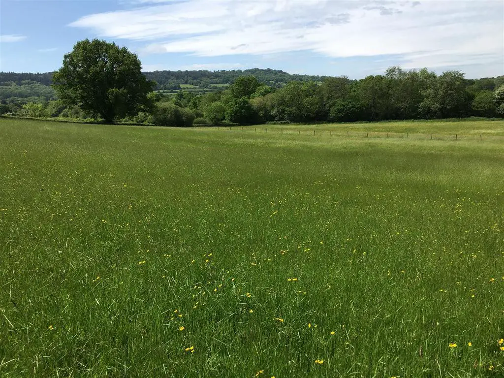
Description - LOT 2 comprises three grass fields which total 5.28 acres (2.13 hectares) which adjoin a stream on the western boundary and have views towards the Blackdown and Quantock Hills.
The field nearest the road is sloping with a gate opening into a larger gently sloping enclosure and the third level enclosure nearest the stream. Both of the lower fields are suitable for mowing and the mature boundary trees create a park like setting.
Additional Lot Available - LOT 1 comprises and agricultural storage building set within a plot of 0.21 acres (0.09 hectares).
The building sits in a plot of 0.21 acres (0.09 hectares) and measures approximately 13.47m x 7.49m with a Lean-to measuring 13.47m x 4.43m. It is constructed with a steel frame, fully enclosed with box profile steel sheets and a concrete floor. In the main section of the building there is a mezzanine level.
Access - There is direct access to the land from a council road.
Services - There is a mains water connection to the land. There is also access to a stream.
Method Of Sale - The land is offered for sale by private treaty.
Tenure - The property is owned freehold and is registered on the Land Registry.
Designations - The land is not within a Nitrate Vulnerable Zone (NVZ).
Local Authority - Somerset West & Taunton Council:
Wayleaves & Rights Of Way - The property is sold subject to and with the benefit of any wayleave agreement and any public or private rights of way that may affect it.
There is a public footpath crossing LOT 2 (the land).
Sporting And Mineral Rights - The sporting and mineral rights insofar as they are owned are included with the freehold.
Land Plan - A plan which is not to scale, is included with these sale particulars for identification purposes only.
Viewing - Viewing is strictly by prior appointment. Please contact Stags[use Contact Agent Button] or [use Contact Agent Button]) to arrange an appointment.
Directions - From Junction 26 of the M5, follow directions to West Buckland. Upon reaching the T-junction in the village, turn right and continue through the village. Just before the bridge over the M5, turn right into Stoford Lane signed towards Trull.
At the next junction follow the road around to the right, signed towards Trull and Taunton. Continue for approximately 700 yards to Cutsey and follow the road around to the right, continue underneath the M5 and Travel on towards Cutsey and cross the bridge over the M5. Continue along this road for 0.7 miles and the land will be found on the right.
Disclaimer - These particulars are a guide only and are not to be relied upon for any purpose.
Situation - The land is located just outside the northern boundary of the Blackdown Hills Area of Outstanding Natural Beauty (AONB), approximately 2 miles to the south-east of West Buckland in Somerset and 4.5 miles to the south-east of Wellington.
The Somerset County Town of Taunton lies 5 miles north-west of the property and Junction 26 of the M5 is within 2.5 miles.
Description - LOT 2 comprises three grass fields which total 5.28 acres (2.13 hectares) which adjoin a stream on the western boundary and have views towards the Blackdown and Quantock Hills.
The field nearest the road is sloping with a gate opening into a larger gently sloping enclosure and the third level enclosure nearest the stream. Both of the lower fields are suitable for mowing and the mature boundary trees create a park like setting.
Additional Lot Available - LOT 1 comprises and agricultural storage building set within a plot of 0.21 acres (0.09 hectares).
The building sits in a plot of 0.21 acres (0.09 hectares) and measures approximately 13.47m x 7.49m with a Lean-to measuring 13.47m x 4.43m. It is constructed with a steel frame, fully enclosed with box profile steel sheets and a concrete floor. In the main section of the building there is a mezzanine level.
Access - There is direct access to the land from a council road.
Services - There is a mains water connection to the land. There is also access to a stream.
Method Of Sale - The land is offered for sale by private treaty.
Tenure - The property is owned freehold and is registered on the Land Registry.
Designations - The land is not within a Nitrate Vulnerable Zone (NVZ).
Local Authority - Somerset West & Taunton Council:
Wayleaves & Rights Of Way - The property is sold subject to and with the benefit of any wayleave agreement and any public or private rights of way that may affect it.
There is a public footpath crossing LOT 2 (the land).
Sporting And Mineral Rights - The sporting and mineral rights insofar as they are owned are included with the freehold.
Land Plan - A plan which is not to scale, is included with these sale particulars for identification purposes only.
Viewing - Viewing is strictly by prior appointment. Please contact Stags[use Contact Agent Button] or [use Contact Agent Button]) to arrange an appointment.
Directions - From Junction 26 of the M5, follow directions to West Buckland. Upon reaching the T-junction in the village, turn right and continue through the village. Just before the bridge over the M5, turn right into Stoford Lane signed towards Trull.
At the next junction follow the road around to the right, signed towards Trull and Taunton. Continue for approximately 700 yards to Cutsey and follow the road around to the right, continue underneath the M5 and Travel on towards Cutsey and cross the bridge over the M5. Continue along this road for 0.7 miles and the land will be found on the right.
Disclaimer - These particulars are a guide only and are not to be relied upon for any purpose.
