Land For Sale £250,000
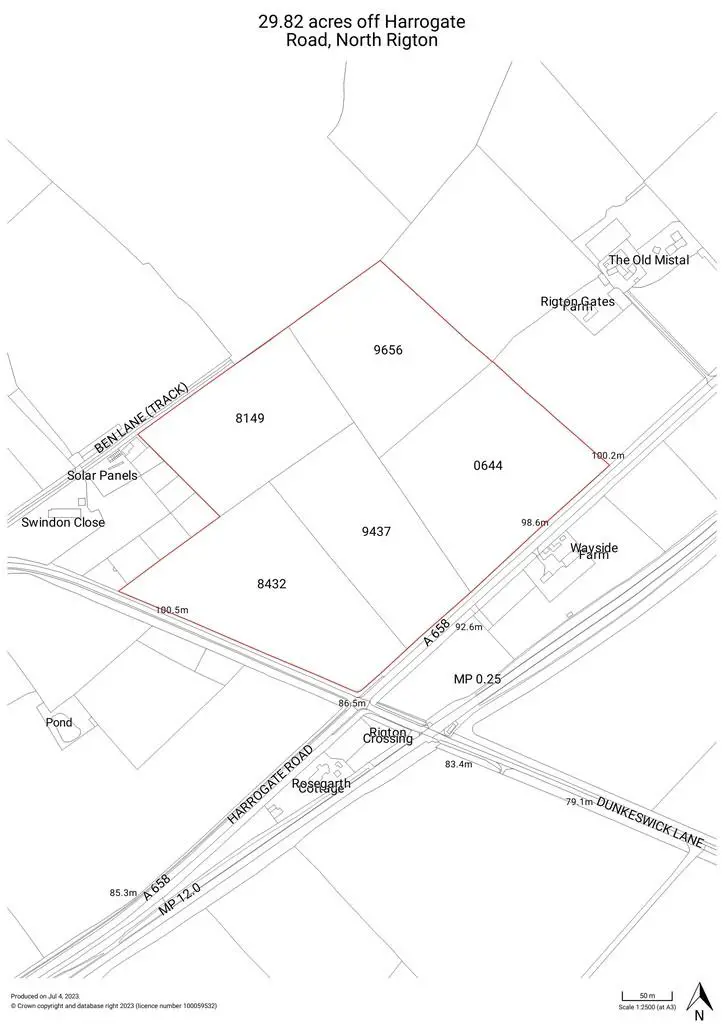
LOCATION AND ACCESS
The land lies north of Harrogate Road and east of Hall
Green Lane, approximately 0.5 miles west of North
Rigton and 2.5 miles south of Harrogate. The property
is accessed directly from the public highways.
DESCRIPTION
The land extends in total to approx. 29.82 Ac (12.06
Ha) of grassland subject to a Tenancy that commenced
on 10th September 1973. It lies to the north of
Harrogate Road on a gentle south east facing slope
with mainly mature hedgerow boundaries
SERVICES
We are not aware of any services connected to the
property
BASIC PAYMENT SCHEME
The tenants have claimed Basic Payment.
NITRATE VULNERABLE ZONE
The land does not lie within a Nitrate Vulnerable Zone
FIELD SCHEDULE
Sheet No. Field No Acres Hectares
SE 2849 8432 7.28 2.95
SE 2849 9437 5.12 2.07
SE 2849 0644 6.93 2.80
SE 2849 8149 5.24 2.12
SE 2849 9656 5.25 2.12
Total 29.82 Acres 12.06 Ha
ADDITIONAL INFORMATION
DIRECTIONS
From Harrogate, travel south along the A61 for
approximately 3.0 miles until you reach the
roundabout south of Pannal. Continue south-west
along the A658, Harrogate Road, for approximately 1.0
mile towards Otley. The land is identified by our Lister
Haigh For Sale board on the north side of the A658.
SPORTING & MINERAL RIGHTS
The sporting rights and mineral rights are included in
the sale so far as they are owned or exist.
RESTRICTIVE COVENANTS
The property is sold subject to and with the benefit of
all restrictive covenants, both public and private,
whether mentioned in these particulars or not.
WAYLEAVES, EASEMENTS & RIGHTS OF WAY
The property is sold subject to all Rights of Way, public
and private, which may affect the property. An
electricity line crosses the land and a private water
supply pipe runs to Rigton Gates Farm.
LOCAL AUTHORITY
North Yorkshire Council
Harrogate Area
METHOD OF SALE
The property is offered for sale by private treaty
although the vendor reserves the right to conclude the
sale by any other method.
TENURE AND OCCUPATION
The tenure of the property is understood to be
freehold subject to a tenancy governed by the
Agricultural Holdings Act 1986 that commenced on 10th
September 1973. The land is let under a written
Tenancy Agreement to Mr T M Stapleton at an
apportioned rent of £1,790 per annum. The rent is an
apportioned one as the vendors are retaining some
land.
VIEWING
The property may be viewed at any reasonable time in
daylight hours whilst in possession of these particulars,
having previously notified the agents office.
PLANS AND AREAS
The plans attached to these particulars are a copy of
the Ordnance Survey Land App plan. The areas given
may vary from previous Ordnance Survey Sheets, field
data sheets and deed plans. All plans are for
identification purposes only and areas are approximate
and subject to verification in the title documents.
IMPORTANT NOTICE
If you have downloaded these particulars from our
website, please also register your interest with our
Knaresborough office.