Land For Sale £100,000
Location - The land parcel is located on Sands Lane, within the West Hull village of Ellerker, which has good access to the A63 at its junction with South Cave.
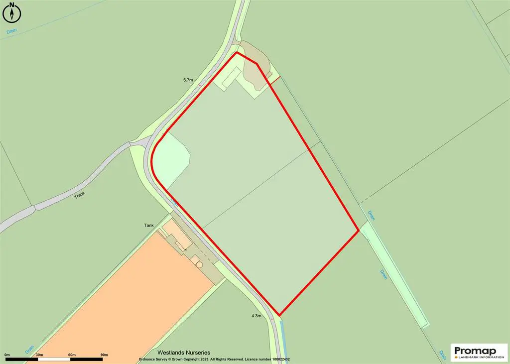
The property lies only a short distance south west of the village and is shown on the location plan within these sale particulars. There is a single access point on the northernmost boundary
Description - The property comprises of a grass field extending to approximately 5.91 acres (2.39 hectares), which is of a uniform shape, with no particular aspect and has been used for grazing and hay making and is suitable as a pony paddock or for equestrian use, subject to any necessary planning consents and approvals.
There are remains of former farm buildings and what was believed to be a dwelling house within an area of brash.
Boundaries - The northern and western boundary has frontage to Sands Lane, the boundaries consist of hedges, dykes and fencing.
Services - There is believed to be mains water supply in Sands Lane. A water search application shows a water main in the opposite highway verge, albeit it seems to indicate there is a 'branch' connection to a position in the verge near to the north east corner of the property. A copy of the search is available upon request from the sole agent any further enquiries should be directed to the appropriate statutory authority.
Easements, Wayleaves & Rights Of Way - The land is sold subject to and with the benefit of all wayleaves, easements or quasi easements and rights of way, light, support, drainage, services supplies whether mentioned in these particulars or not and without any obligations to define the same respectively. There is an electricity wayleave in favour of Northern Powergrid Plc, further details are available from the sole agent. There are no other known rights of way or easements affecting the property to the vendors knowledge.
Sporting & Mineral Rights - The sporting, mining and mineral rights (so far as these are owned) are included in the sale.
Development Uplift Clause - A "Development Uplift" (overage) is to be imposed on the basis that should and if the land use is changed away from agriculture, horticulture, or equine use either through any planning consent or permitted development rights (under the General Development Consent Order) then a "Development Uplift'"(overage) will be payable to the vendor or their successors in title. This would be based upon 30% of the increase in the Market Value of the property immediately before the planning consent/permitted development, was granted (excluding any hope value) and the Market Value of the property immediately after planning/permitted development consent is granted, but taking into account the terms of any such consent. The overage/development uplift is imposed for a period of 25 years.
Tenure & Possession - The property is available Freehold with Vacant Possession on completion.
Method Of Sale - The land is offered for sale, by informal tender. You must register with the sole agent in order to receive a tender form. Tender forms must be returned to the Leonards Hull Office in a sealed envelope, externally marked as 'Land at Ellerker Tender' by no later than 12 Noon on Tuesday 29th August 2023. The vendor retains the right, that they do not have to accept the highest or any offer received.
Deductions - The purchaser shall make no claim for deductions or dilapidations whatsoever.
Plans & Measurements - Any plans forming part of these particulars are included for identification purposes only and do not form part of the contract for sale. Areas or measurements where stated are given as a guide only and should be checked by you or your own agent(s).
Planning - Current planning policy is governed by the East Riding Local Plan and Strategy Document which was adopted April 2016 and the Policies Map adopted July 2016. Under the prevailing Local Plan, the site lies outside the development limit of the village and is not shown to be classified within any particular designation and as a consequence it lies within 'open countryside'. The Policies map shows it to be within a 'Minerals Safeguarding Area'. Further enquires should be directed to the East Riding of Yorkshire Council's Planning department or you should seek your own independent advice from a Chartered Town Planner.
Local & Statutory Authorities - The East Riding of Yorkshire Council, County Hall, Beverley, HU17 9BA [use Contact Agent Button] Web: Yorkshire Water Services [use Contact Agent Button] Web: Northern Powergrid Plc. Tel: 0800 375 Web:
Health & Safety - Please take care when viewing the property being as vigilant as possible when making an inspection, for your own personal safety.
What3words - Field Access Point: ///moment.searched.foreheads
Viewing - During daylight hours with a set of sales particulars to hand.
