Land For Sale £950,000
A patch of Highland Perthshire offering a mosaic of land uses & opportunities
Description
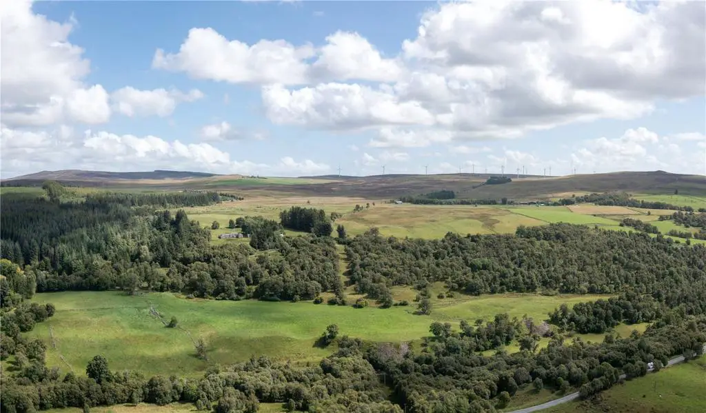
Blackhall Farm is an extensive block of upland farmland extending to about 507 acres in total and comprises 59 acres of inbye grazing and about 394 acres of hill grazing.Lying close to the south western boundary of Blackhall is a traditional ‘U’ shaped steading which lies in an elevated position above the public road. Constructed of traditional stone and slate and now in a poor state of repair there is significant potential to create a stunning home. The central block would lend its self to open plan living with the outer wings for bedroom accommodation. The courtyard to the front of the building has a south westerly aspect and could be utilised for outdoor entertaining / dining. The steading is accessed through a gate next to Blackhall Farmhouse (in third party ownership) which opens from the public road into the surrounding field. To the side and rear of the steading and its outbuildings are beautiful, mature trees which provide welcome shelter and privacy.
It is anticipated that the local authority would engage positively with a purchaser who wished to utilise these buildings for an alternative use such as residential. NPF4 (National Planning Framework 4), which was introduced in February 2023, supports the refurbishment of existing building stocks by reducing the release of embedded carbon as well as delivering more efficient, affordable homes. The farm is divided by a minor public road (C446), and is bounded to the west by the Black Water, where there are salmon and trout fishing rights. The remainder of the land is surrounded by neighbouring hill ground and commercial forestry. The land lies between 230m and 381m above sea level and is classified by the James Hutton Institute for Soil Research as Class 4(1) and Class 5(2) with a strip of Class 6(3) to the north west.
The majority of the land has a westerly aspect and a gently undulating and sloping terrain. There are a number of burns which provide water for livestock. Access to the land can be taken from a number of roadside gates. The farm is currently let to a neighbouring farmer on an annual grazing agreement. Blackhall offers an excellent opportunity for a variety of buyers including those looking to add additional acres on to an existing enterprise, or those looking to carry out woodland creation or renewable energy projects such as wind or, given its southfacing aspect, solar developments. Similarly, the land may appeal to a lifestyle buyer looking to acquire their own part of Scotland that is within easy reach of the major population centres.
WILDLIFE AND NATURE
The varied and natural habitats across Blackhall support a wonderful ecosystem which attracts a diversity of wildlife, flora and fauna. Across much of the land there are red grouse, curlews, snipe, sky larks and roe deer. In the spring and summer months the grasses, bogs and heather come to life with beautiful colours typical of Perthshire’s highland landscape. The midpoint of the Black Water forms the western boundary and offers the occasional chance of a trout or salmon when conditions allow. Similarly, the midpoint of the Drumturn Burn forms the north western boundary which meanders its way down to the Black Water.
FORESTRY
Whilst no physical surveys have been undertaken by the seller, initial desktop surveys suggest the land would be well suited to timber production. The terrain is gently sloping, flattening to the eastern march, and provides good drainage over the soils which are predominantly peaty gleyed podzols and humus-iron podzols. Other than the Dunmoss SSSI and SAC (situated at the eastern end of Blackhall) there are no conservation designations over the land and it is classified in the Perth and Kinross Local Development Plan as having the potential or preferred status for new woodland creation. This is supported by the land capability for forestry map series that shows the land as having F5 and F6 capability for forestry. The land is equally suited to native woodland planting and the sequestration of carbon and, therefore, could potentially generate carbon units through the UK Woodland Carbon Code, the British standard for climate change mitigation afforestation projects. The Timber Transport Forum classify the C446 as a Consultation Route for timber extraction.
RENEWABLE ENERGY
A planning application (Ref:15/01691/FLM) was submitted in September 2015 by ABO Wind for the erection of eleven wind turbines up to 130m in height on a site known as Green Burn Wind Farm which spanned over Blackhall Farm and the neighbouring Shieldrum Farm. In 2017 the application was refused but later granted in February 2018 following an appeal. The proposed scheme included six turbines on the subjects of sale stretching from the northern boundary of Blackhall to the public road. ABO Wind subsequently decided not to take Green Burn Wind Farm forward and their option agreement lapsed. Another developer is understood to be progressing with the development of turbines on Shieldrum Farm alone. There may be potential for an incoming purchaser to engage with the developer of Shieldrum Farm or explore the potential of turbines on Blackhall Farm.
TOURISM
The land offered for sale lies on the southern edge of the Cairngorms National Park which covers over 4,500 sq kms of land. Within the National Park there is a plethora of recreational and leisure activities catering for all interests and all ages. The National Park attracts over 1.9 million visitors per annum. Given the popularity of the National Park and the variety of land types and scale of land offered at Blackhall there is a wonderful opportunity to create a rural business or tourism enterprise that makes the most of its accessible location. NPF4 provides support for economic growth of the tourism industry in rural areas.
Location
Blackhall Farm lies in Glenshee in Highland Perthshire, a county renowned for its wonderful and varied landscapes which include tranquil river banks, productive farmland and rolling heather moors.
The village of Bridge of Cally, lies 4 miles to the south of Blackhall and is centred around the bridge over the River Ardle before, it joins the Black Water to form the River Ericht. Sitting at the junction of three glens, Glenshee, Strathardle and Glenericht, the village has a general store, a post office and a hotel. Known as the gateway to Glenshee, and locally as 'Blair', Blairgowrie (11 miles) has an excellent selection of local shops and is the centre for the Perthshire soft fruit growing industry.
Local schooling is available in Kirkmichael (primary) (6 miles) and Blairgowrie (secondary) as well as private schooling in Dundee and the boarding schools of Glenalmond and Strathallan. The larger regional centres of Perth (26 miles) and Dundee (26 miles) are within easy reach and offer a range of professional services, shops, cultural and leisure facilities.
Dundee Airport offers flights to and from London Heathrow and Belfast. Perth Airport at Scone (24 miles) can accommodate small private aircraft.
There is an abundance of sport and leisure attractions available locally including the extensive downhill ski centre at Glenshee (15 miles), salmon fishing on the rivers Tay and Ericht, championship golf courses at Rosemount (Blairgowrie), Carnoustie, Gleneagles and St. Andrews, together with hill walking and traditional field sports in the Grampians and the Cairngorms National Park.
Acreage: 507 Acres
Directions
Viewing
Strictly by appointment with Savills –[use Contact Agent Button]. Given the potential hazards of a working farm, we request you take care when viewing the property.
Directions
Blackhall Farm is situated a short distance off the A93 which connects Blairgowrie and Braemar. From the south, head north from Blairgowrie following the A93 through Bridge of Cally. After passing through Bridge of Cally continue on the A93 for approximately 3.5 miles and turn right at the signpost for ‘Tullymurdoch’ and ‘Alyth’. From the north, head south on the A93 past Glenshee Ski Centre and the Spittal of Glenshee. Continue on the road for a further 9.5 miles and turn left at the signpost for ‘Tullymurdoch’ and ‘Alyth’. After half a mile the steading can be found on the left hand side.
The postcode for sat nav purposes is PH10 7JX.
What3words – ///replayed.rating.cloth
Description
Blackhall Farm is an extensive block of upland farmland extending to about 507 acres in total and comprises 59 acres of inbye grazing and about 394 acres of hill grazing.Lying close to the south western boundary of Blackhall is a traditional ‘U’ shaped steading which lies in an elevated position above the public road. Constructed of traditional stone and slate and now in a poor state of repair there is significant potential to create a stunning home. The central block would lend its self to open plan living with the outer wings for bedroom accommodation. The courtyard to the front of the building has a south westerly aspect and could be utilised for outdoor entertaining / dining. The steading is accessed through a gate next to Blackhall Farmhouse (in third party ownership) which opens from the public road into the surrounding field. To the side and rear of the steading and its outbuildings are beautiful, mature trees which provide welcome shelter and privacy.
It is anticipated that the local authority would engage positively with a purchaser who wished to utilise these buildings for an alternative use such as residential. NPF4 (National Planning Framework 4), which was introduced in February 2023, supports the refurbishment of existing building stocks by reducing the release of embedded carbon as well as delivering more efficient, affordable homes. The farm is divided by a minor public road (C446), and is bounded to the west by the Black Water, where there are salmon and trout fishing rights. The remainder of the land is surrounded by neighbouring hill ground and commercial forestry. The land lies between 230m and 381m above sea level and is classified by the James Hutton Institute for Soil Research as Class 4(1) and Class 5(2) with a strip of Class 6(3) to the north west.
The majority of the land has a westerly aspect and a gently undulating and sloping terrain. There are a number of burns which provide water for livestock. Access to the land can be taken from a number of roadside gates. The farm is currently let to a neighbouring farmer on an annual grazing agreement. Blackhall offers an excellent opportunity for a variety of buyers including those looking to add additional acres on to an existing enterprise, or those looking to carry out woodland creation or renewable energy projects such as wind or, given its southfacing aspect, solar developments. Similarly, the land may appeal to a lifestyle buyer looking to acquire their own part of Scotland that is within easy reach of the major population centres.
WILDLIFE AND NATURE
The varied and natural habitats across Blackhall support a wonderful ecosystem which attracts a diversity of wildlife, flora and fauna. Across much of the land there are red grouse, curlews, snipe, sky larks and roe deer. In the spring and summer months the grasses, bogs and heather come to life with beautiful colours typical of Perthshire’s highland landscape. The midpoint of the Black Water forms the western boundary and offers the occasional chance of a trout or salmon when conditions allow. Similarly, the midpoint of the Drumturn Burn forms the north western boundary which meanders its way down to the Black Water.
FORESTRY
Whilst no physical surveys have been undertaken by the seller, initial desktop surveys suggest the land would be well suited to timber production. The terrain is gently sloping, flattening to the eastern march, and provides good drainage over the soils which are predominantly peaty gleyed podzols and humus-iron podzols. Other than the Dunmoss SSSI and SAC (situated at the eastern end of Blackhall) there are no conservation designations over the land and it is classified in the Perth and Kinross Local Development Plan as having the potential or preferred status for new woodland creation. This is supported by the land capability for forestry map series that shows the land as having F5 and F6 capability for forestry. The land is equally suited to native woodland planting and the sequestration of carbon and, therefore, could potentially generate carbon units through the UK Woodland Carbon Code, the British standard for climate change mitigation afforestation projects. The Timber Transport Forum classify the C446 as a Consultation Route for timber extraction.
RENEWABLE ENERGY
A planning application (Ref:15/01691/FLM) was submitted in September 2015 by ABO Wind for the erection of eleven wind turbines up to 130m in height on a site known as Green Burn Wind Farm which spanned over Blackhall Farm and the neighbouring Shieldrum Farm. In 2017 the application was refused but later granted in February 2018 following an appeal. The proposed scheme included six turbines on the subjects of sale stretching from the northern boundary of Blackhall to the public road. ABO Wind subsequently decided not to take Green Burn Wind Farm forward and their option agreement lapsed. Another developer is understood to be progressing with the development of turbines on Shieldrum Farm alone. There may be potential for an incoming purchaser to engage with the developer of Shieldrum Farm or explore the potential of turbines on Blackhall Farm.
TOURISM
The land offered for sale lies on the southern edge of the Cairngorms National Park which covers over 4,500 sq kms of land. Within the National Park there is a plethora of recreational and leisure activities catering for all interests and all ages. The National Park attracts over 1.9 million visitors per annum. Given the popularity of the National Park and the variety of land types and scale of land offered at Blackhall there is a wonderful opportunity to create a rural business or tourism enterprise that makes the most of its accessible location. NPF4 provides support for economic growth of the tourism industry in rural areas.
Location
Blackhall Farm lies in Glenshee in Highland Perthshire, a county renowned for its wonderful and varied landscapes which include tranquil river banks, productive farmland and rolling heather moors.
The village of Bridge of Cally, lies 4 miles to the south of Blackhall and is centred around the bridge over the River Ardle before, it joins the Black Water to form the River Ericht. Sitting at the junction of three glens, Glenshee, Strathardle and Glenericht, the village has a general store, a post office and a hotel. Known as the gateway to Glenshee, and locally as 'Blair', Blairgowrie (11 miles) has an excellent selection of local shops and is the centre for the Perthshire soft fruit growing industry.
Local schooling is available in Kirkmichael (primary) (6 miles) and Blairgowrie (secondary) as well as private schooling in Dundee and the boarding schools of Glenalmond and Strathallan. The larger regional centres of Perth (26 miles) and Dundee (26 miles) are within easy reach and offer a range of professional services, shops, cultural and leisure facilities.
Dundee Airport offers flights to and from London Heathrow and Belfast. Perth Airport at Scone (24 miles) can accommodate small private aircraft.
There is an abundance of sport and leisure attractions available locally including the extensive downhill ski centre at Glenshee (15 miles), salmon fishing on the rivers Tay and Ericht, championship golf courses at Rosemount (Blairgowrie), Carnoustie, Gleneagles and St. Andrews, together with hill walking and traditional field sports in the Grampians and the Cairngorms National Park.
Acreage: 507 Acres
Directions
Viewing
Strictly by appointment with Savills –[use Contact Agent Button]. Given the potential hazards of a working farm, we request you take care when viewing the property.
Directions
Blackhall Farm is situated a short distance off the A93 which connects Blairgowrie and Braemar. From the south, head north from Blairgowrie following the A93 through Bridge of Cally. After passing through Bridge of Cally continue on the A93 for approximately 3.5 miles and turn right at the signpost for ‘Tullymurdoch’ and ‘Alyth’. From the north, head south on the A93 past Glenshee Ski Centre and the Spittal of Glenshee. Continue on the road for a further 9.5 miles and turn left at the signpost for ‘Tullymurdoch’ and ‘Alyth’. After half a mile the steading can be found on the left hand side.
The postcode for sat nav purposes is PH10 7JX.
What3words – ///replayed.rating.cloth