Land For Sale £800,000
The Brooks, Dagbrook Lane, Henfield, West Sussex
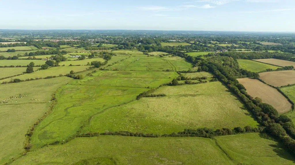
A strategically important block of traditional grassland and flood meadow offering significant scope for wilding, water neutrality or biodiversity enhancement, located within the ‘Weald to
Waves’ nature recovery corridor on the southern side of Henfield
Henfield 1 mile, Knepp 8 miles, Horsham 12 miles
Traditional Grazing Land | Wetland Habitat
Significant Environmental Potential
Approximately 114 acres (46 ha) in total
For sale as a whole
Offers Over £800,000
Situation
The land is situated on the southern side of Henfield, close to the River Adur, with the Downslink bridleway (formerly the Horsham to Shoreham railway line) running along the eastern boundary. The location of the land, close to the River Adur and the Woods Mill stream, leads to seasonal flooding on the lower lying fields, turning the land into an important wetland habitat in winter months, especially for waterfowl.
It is thought The Brooks now offer potential for creation of year-round wetland habitat, which might lend itself to water neutrality or biodiversity net gain purposes. The position of this land, at the heart of the new 'Weald to Waves' 100 mile nature recovery corridor, offers scope for future conservation or wilding uses on land including rare flood meadow, in a key West Sussex location.
The Land
The land lies in a single contiguous block with gated access directly from the hard-surfaced Downslink track which runs the length of the eastern boundary. The land is bounded by a mixture of stock-proof fencing, and by native hedgerows and small deciduous woodland shaws. All of the land is permanent pasture, currently used to provide summer grazing for sheep and cattle, with very limited use of any sprays or fertiliser in recent years. The fields running along the eastern boundary are slightly higher and can offer near year round grazing. The balance of the land is lower lying and is more typical of flood-meadow, subdivided by a system of drainage channels, which connect more widely via greensand and chalk streams with Broadmere Common, the Woods Mill stream, and further south into the Adur itself. It is believed that the course of the Adur has been changed through human intervention over the centuries and that before it was embanked, a meander of the Adur ran through the land offered for sale. A previous walk-over survey by an ecological advisor, highlighted the ecological and biodiversity potential that the land offers with considered future management. The conventional land management approach of recent years has resulted in resilient, but comparatively low, numbers of a wide range of plants, birds and mammals. With targeted management, the land could become a key part of nature recovery habitat in West Sussex, along the Weald to Waves corridor. Current key ecological features include rare chalk and greensand streams, and species including Common Reed, Field Mushroom, Common Fleabane, Snipe, Water Figwort, Brooklime, Starwort, Greylag Geese, St Johns Wort, Common Chickweed, Fieldfare, Tubular Water Dropwort, Great Water Parsnip, Brown Hairstreak Butterfly, Adder, Barn Owl, Curlew, Garganey, Grey Heron, Lesser Spotted Woodpecker, Hobby, Kingfisher, Lapwing, Little Egret, Peregrine, Pintail and Redshank. The land now represents a unique opportunity for future creation of permanent wetland habitat or for ecological enhancement, in a unique location.
General
Method of sale: The property is offered for sale confidentially as a whole by private treaty. A deadline may be set for best offers and interested parties are therefore encouraged to register their interest with the selling agent at an early opportunity.
Access: Historically the land has formed part of the adjacent Brookside Farm, with access taken from the east over Dagbrook Lane, the majority of which is within the private ownership of Brookside Farm. At point of sale a new right of way for agricultural, land and estate management purposes will be granted over Dagbrook Lane and through Brookside Farm to the Downslink. The freehold to the section of the Downslink itself, which contiguous with the eastern boundary of the sale area, is included within the sale. From the Downslink, there are separate gated access points into the fields running along the eastern boundary. The maintenance of the length of this right of way will be divided amongst those parties using the track on an ‘as to user’ basis. It is understood the land also historically utilised rights of access of third party land from the north via Windmill Lane, and across third party farmland from the south east. Neither of these historic rights of way have been used for many years.
Services: The land is not believed to have any current service connections. Interested parties should rely on their own enquiries as to the location, suitability and availability of service connections.
Wayleaves, Easements and Rights of Way:
The property is being sold subject to and with the benefit of all rights including; rights of way, whether public or private, light, support, drainage, water and electricity supplies and other rights and obligations, easements and quasi-easements and restrictive covenants and all existing and proposed wayleaves for masts, pylons, stays, cables, drains, water and gas and other pipes whether referred to in these particulars or not. The freehold to the Downslink bridleway contiguous with the eastern boundary of the land is included in the sale. Footpath 2563 runs through the fields on the eastern side of the land in a north-south direction.
Restrictive Covenant: The land will be sold subject to a new restrictive covenant at date of sale, prohibiting commercial uses, save for agriculture, horticulture, ecological and related purposes.
Basic Payment: The Vendors have claimed and will retain the 2023 Scheme Year Basic Payment. The Purchasers will be required to give an undertaking that they will comply with ongoing BPS Cross Compliance Rules until 31st December 2023.
Designations: The land is not situated within an Area of Outstanding Natural Beauty or a SSSI.
Sporting, timber and mineral rights: All timber and sporting rights are included in the freehold sale, in so far as they are owned. We understand that the mineral rights are not owned by the vendors and are excluded from the sale.
Local authority: Horsham District Council, Parkside, Horsham, West Sussex RH12 1RL.[use Contact Agent Button]
VAT: Any guide price quoted or discussed is exclusive of VAT. In the event that a sale of the property, or any part of it, or any right attached to it, becomes a chargeable supply for the purposes of VAT, such tax will be payable in addition.
Health and safety: Given the potential hazards of a working farm, we ask you to be as vigilant as possible when making your inspection for your own personal safety. Please contact Strutt & Parker on the details below to arrange a viewing.
Solicitors: Thomson Snell & Passmore LLP, Heathervale House, 2-4 Vale Avenue, Tunbridge Wells, Kent, TN1 1DJ
South East Estates & Farm Agency
201 High Street, Lewes, East Sussex, BN7 2NR
[use Contact Agent Button]
[use Contact Agent Button]
struttandparker.com
Directions
The postcode for Brookside Farm is BN5 9SH. From the centre of Henfield, proceed south on the A257 (Barrow Hill) towards Smalldole. Turn right onto Dagbrook Lane, and proceed all the way to the end of the lane. If viewing, please meet in the farmyard adjacent to the Dutch Barn. The right of way granted at point of sale continues along the farm track, turning right before the converted barn, and dropping down to a five bar gate onto the ownslink trackway.
Viewing
Strictly by confirmed appointment with the
vendor’s agents, Strutt & Parker, on 01273
407024.
