Land For Sale £450,000
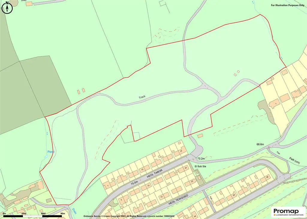
The subject premises comprises a substantial size site and a vast area of land, extending to approximately 10.57 acres (4.27 hectares) in total, which is located to the rear of an existing housing estate within the suburban area of Cwmavon, along the outskirts of Port Talbot.
The site is generally of an irregular shape, which slopes further to the north, comprising a mixture of woodland in majority together with additional sloping grassland in part (more noticeably along the northeast section of the site), with the majority of the site appearing to be defined by various trees and hedgerows. The site is currently accessed via a number of unmade vehicular access tracks, which intersect the majority of the site. The main entrance to site can also be accessed off directly Heol Tabor to the south.
We further advise that the subject premises also accommodates a large amount of Japanese Knotweed and we advise that no further mitigative measures have been implemented to eradicate the presence of this invasive species.
We have also been advised that part of the site was previously granted planning permission for the construction of various 2 and 3 bedroom semi-detached dwellings, which were proposed to be constructed over the northeast area of the site (equating to approximately 3.35 acres). Planning permission for the proposed residential development was granted on 26th January 1977 (Ref: T1976/1232). We therefore advise that further enquiries will need to be made with the relevant Local Authority Planning Department to verify this information.
Description - The subject premises comprises a substantial size site and a vast area of land, extending to approximately 10.57 acres (4.27 hectares) in total, which is located to the rear of an existing housing estate within the suburban area of Cwmavon, along the outskirts of Port Talbot.
The site is generally of an irregular shape, which slopes further to the north, comprising a mixture of woodland in majority together with additional sloping grassland in part (more noticeably along the northeast section of the site), with the majority of the site appearing to be defined by various trees and hedgerows. The site is currently accessed via a number of unmade vehicular access tracks, which intersect the majority of the site. The main entrance to site can also be accessed off directly Heol Tabor to the south.
We further advise that the subject premises also accommodates a large amount of Japanese Knotweed and we advise that no further mitigative measures have been implemented to eradicate the presence of this invasive species.
We have also been advised that part of the site was previously granted planning permission for the construction of various 2 and 3 bedroom semi-detached dwellings, which were proposed to be constructed over the northeast area of the site (equating to approximately 3.35 acres). Planning permission for the proposed residential development was granted on 26th January 1977 (Ref: T1976/1232). We therefore advise that further enquiries will need to be made with the relevant Local Authority Planning Department to verify this information.
Location - The premises is located within a suburban area, to the rear of an existing mixed private and ex-Local Authority housing estate along the outskirts of Cwmavon.
Cwmavon has access to a limited range of amenities and facilities within the immediate area. The larger town of Port Talbot is within a reasonable distance. Port Talbot town centre benefits from a main line railway station and local bus services, which provide close links to the larger city of Swansea. There are local bus routes from the street which provide access in to the area of Cwmavon and Port Talbot.
Cwmavon has a population of 5,615 (2011 Census), which was historically an industrial village but is now predominantly occupied by various residential housing.
The site also provides good lines of communication via the main B4286 and the A4107, which provides ease of access to the M4 Motorway (J41), which approximately 2.2 miles away in a southerly direction.
Accommodation - The subject premises affords the following approximate dimensions and areas.
Site Area: 10.57 Acres (4.27 Hectares)
Site Depth (Max): 148.34m (486 ft.)
Site Width (Max): 412.45m (1,353 ft.)
Frontage (Heol Tabor): 45.98m (150 ft.)
Planning - We further advise that the subject premises is located within an area predominantly occupied by residential housing and we are therefore of the opinion that part of the land has the potential to be development to comprise a residential housing site (subject to the necessary statutory consents and permissions).
Based on the information enclosed within the Neath Port Talbot County Borough Council LDP (2011-2026), the subject premises appears to be located along the edge of the Settlement Limit (Policy SC1). Proposals for development outside settlement limits that can be justified under the terms of Policy SC1 will be expected to be located near to existing development whenever possible, preferably within or adjacent to Dormitory settlements where appropriate.
In accordance with Policy SC1 (Settlement Limits), development within settlement limits that is proportionate in scale and form to the role and function of the settlement as set out in the Settlement Hierarchy will be acceptable in principle.
Outside settlement limits, development will only be permitted under the following circumstances:
1. It constitutes a sustainable small scale employment use adjacent to a settlement limit; or
2. It constitutes live-work unit(s) immediately adjacent to a settlement limit in the Valleys Strategy Area only; or
3. It constitutes the small-scale expansion of an existing business or the suitable conversion of an existing building; or
4. It constitutes the appropriate replacement of an existing dwelling; or
5. It is an affordable housing exception site; or
6. It is an appropriate rural enterprise dwelling; or
7. It is an appropriate 'One Planet Development'; or
8. It is a sustainable tourism or farm diversification proposal that is suitable in a countryside location; or
9. It is associated with the provision of public utilities, infrastructure and waste management facilities that cannot reasonably be located elsewhere; or
10. It is associated with either agriculture, forestry, minerals or energy generation; or
11. It relates to the appropriate provision of accommodation for Gypsies / Travellers; or
12. It constitutes the provision of open space and small scale ancillary facilities adjoining the settlement limit.
Vat - All figures quoted are exclusive of VAT. Our client reserves the right to levy VAT on this transaction (if applicable).
Terms And Tenure - The subject premises is available Freehold with vacant possession.
Viewing - By appointment with Sole Agents:
Astleys Chartered Surveyors
[use Contact Agent Button]
[use Contact Agent Button]
The site is generally of an irregular shape, which slopes further to the north, comprising a mixture of woodland in majority together with additional sloping grassland in part (more noticeably along the northeast section of the site), with the majority of the site appearing to be defined by various trees and hedgerows. The site is currently accessed via a number of unmade vehicular access tracks, which intersect the majority of the site. The main entrance to site can also be accessed off directly Heol Tabor to the south.
We further advise that the subject premises also accommodates a large amount of Japanese Knotweed and we advise that no further mitigative measures have been implemented to eradicate the presence of this invasive species.
We have also been advised that part of the site was previously granted planning permission for the construction of various 2 and 3 bedroom semi-detached dwellings, which were proposed to be constructed over the northeast area of the site (equating to approximately 3.35 acres). Planning permission for the proposed residential development was granted on 26th January 1977 (Ref: T1976/1232). We therefore advise that further enquiries will need to be made with the relevant Local Authority Planning Department to verify this information.
Description - The subject premises comprises a substantial size site and a vast area of land, extending to approximately 10.57 acres (4.27 hectares) in total, which is located to the rear of an existing housing estate within the suburban area of Cwmavon, along the outskirts of Port Talbot.
The site is generally of an irregular shape, which slopes further to the north, comprising a mixture of woodland in majority together with additional sloping grassland in part (more noticeably along the northeast section of the site), with the majority of the site appearing to be defined by various trees and hedgerows. The site is currently accessed via a number of unmade vehicular access tracks, which intersect the majority of the site. The main entrance to site can also be accessed off directly Heol Tabor to the south.
We further advise that the subject premises also accommodates a large amount of Japanese Knotweed and we advise that no further mitigative measures have been implemented to eradicate the presence of this invasive species.
We have also been advised that part of the site was previously granted planning permission for the construction of various 2 and 3 bedroom semi-detached dwellings, which were proposed to be constructed over the northeast area of the site (equating to approximately 3.35 acres). Planning permission for the proposed residential development was granted on 26th January 1977 (Ref: T1976/1232). We therefore advise that further enquiries will need to be made with the relevant Local Authority Planning Department to verify this information.
Location - The premises is located within a suburban area, to the rear of an existing mixed private and ex-Local Authority housing estate along the outskirts of Cwmavon.
Cwmavon has access to a limited range of amenities and facilities within the immediate area. The larger town of Port Talbot is within a reasonable distance. Port Talbot town centre benefits from a main line railway station and local bus services, which provide close links to the larger city of Swansea. There are local bus routes from the street which provide access in to the area of Cwmavon and Port Talbot.
Cwmavon has a population of 5,615 (2011 Census), which was historically an industrial village but is now predominantly occupied by various residential housing.
The site also provides good lines of communication via the main B4286 and the A4107, which provides ease of access to the M4 Motorway (J41), which approximately 2.2 miles away in a southerly direction.
Accommodation - The subject premises affords the following approximate dimensions and areas.
Site Area: 10.57 Acres (4.27 Hectares)
Site Depth (Max): 148.34m (486 ft.)
Site Width (Max): 412.45m (1,353 ft.)
Frontage (Heol Tabor): 45.98m (150 ft.)
Planning - We further advise that the subject premises is located within an area predominantly occupied by residential housing and we are therefore of the opinion that part of the land has the potential to be development to comprise a residential housing site (subject to the necessary statutory consents and permissions).
Based on the information enclosed within the Neath Port Talbot County Borough Council LDP (2011-2026), the subject premises appears to be located along the edge of the Settlement Limit (Policy SC1). Proposals for development outside settlement limits that can be justified under the terms of Policy SC1 will be expected to be located near to existing development whenever possible, preferably within or adjacent to Dormitory settlements where appropriate.
In accordance with Policy SC1 (Settlement Limits), development within settlement limits that is proportionate in scale and form to the role and function of the settlement as set out in the Settlement Hierarchy will be acceptable in principle.
Outside settlement limits, development will only be permitted under the following circumstances:
1. It constitutes a sustainable small scale employment use adjacent to a settlement limit; or
2. It constitutes live-work unit(s) immediately adjacent to a settlement limit in the Valleys Strategy Area only; or
3. It constitutes the small-scale expansion of an existing business or the suitable conversion of an existing building; or
4. It constitutes the appropriate replacement of an existing dwelling; or
5. It is an affordable housing exception site; or
6. It is an appropriate rural enterprise dwelling; or
7. It is an appropriate 'One Planet Development'; or
8. It is a sustainable tourism or farm diversification proposal that is suitable in a countryside location; or
9. It is associated with the provision of public utilities, infrastructure and waste management facilities that cannot reasonably be located elsewhere; or
10. It is associated with either agriculture, forestry, minerals or energy generation; or
11. It relates to the appropriate provision of accommodation for Gypsies / Travellers; or
12. It constitutes the provision of open space and small scale ancillary facilities adjoining the settlement limit.
Vat - All figures quoted are exclusive of VAT. Our client reserves the right to levy VAT on this transaction (if applicable).
Terms And Tenure - The subject premises is available Freehold with vacant possession.
Viewing - By appointment with Sole Agents:
Astleys Chartered Surveyors
[use Contact Agent Button]
[use Contact Agent Button]