Land For Sale £125,000
INDIVIDUAL BUILDING PLOT
Outline Planning Consent for a detached house and garage on a level plot within the Fal valley on the edge of Tregony village.
Remains of traditional stone Barn with further potential.
General Remarks And Location - This is a rare chance to purchase a plot of land on the edge of Tregony village with outline planning consent for a detached house. It also has the benefit of some ruined remains of a traditional barn which may well offer further potential.
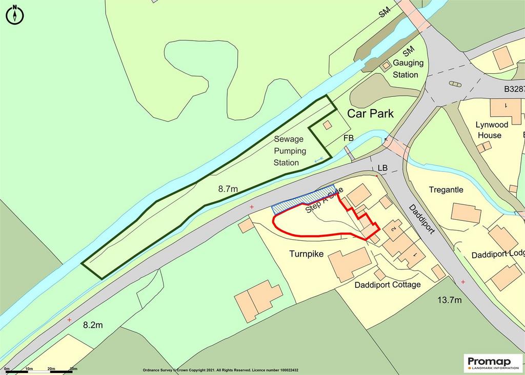
The property will become part of the small nucleus of dwellings set astride the A3078 Tregony to St Mawes road known as Daddiport, close to Tregony Bridge but this particular plot is off from the main road fronting the minor road leading to Ruanlanihorne and with an attractive wooded outlook.
Tregony is a thriving community with a good range of village facilities including general store/post office, public house, Church, primary and secondary schools and a wide range of social activities. The village is easily accessible to the whole area of the Roseland Peninsula which is recognised as being an Area of Outstanding Natural Beauty and subsequently a much sought after residential area. The city of Truro is approximately eight miles distant and St. Austell slightly further.
The Plot - The plot is level for the area of the dwelling and easily developed. As already mentioned it directly fronts the minor road leading to Ruanlanihorne and is set back from an entrance shared between the plot and two other properties (the bungalow known as Turnpike on the hillside above where there is also an adjacent plot of land being developed). The shared driveway also provides access to a newly developed parking bay for 2 cars to serve the plot in addition to a proposed garage being attached to the house. There is a garden area on the sloping ground behind the parking bay.
Planning Consent - Outline Planning Consent was granted by Cornwall Council on the 21st June 2021 (Application number PA20/04221) for "construction of new dwelling".
Permission was granted subject to the following conditions:
1. Details of the access, appearance, landscaping, layout and scale(the reserved matters) shall be submitted to and approved in writing by the local planning authority before any development begins and the development shall be carried out as approved.
2. An application for reserved matters must be made no later than the expiration of 3 years from the date of this decision and the development hereby approved shall commence no later than 2 years from the final approval of the reserved matters or, in the case of approval on different dates, the final approval of the last such matter to be approved.
3. No development approved by this planning permission shall commence until such time as details of the finished floor levels (FFL) has been submitted to, and approved in writing by, the local planning authority. The ground floor (FFL) shall be set at a minimum elevation of 10.50m AOD (to include 1:100 year 40% flood event and 600mm freeboard) in accordance with the recommendation in the Flood Risk Assessment.
4. The development permitted by this planning permission shall be carried out in accordance with the Flood Risk Assessment (FRA) dated 5th February 2021, ref J-1597 and produced by EDS submitted as part of this outline application and the following mitigation measures detailed within the FRA.
1. Finished floor levels are set no lower than 10.5m above Ordnance Datum (AOD).
2. Flood resistant flooring and finishes should be utilised where possible throughout the property to a level of 10.5m AOD.
3. All electrical circuitry and apparatus should be installed at a 10.5m AOD or as high as reasonable practicable. Alternatively ground based electrical installations should be designed to withstand flooding.
4. An access/egress route should be made available from the new dwelling which is either higher than the flood levels of 9.91m AOD or above a level of 9.848m AOD to allow for access in an extreme flood event as detailed in Section 5.0.
5. Residents and inhabitants of the property should be connected to the Environment Agency flood alert system for the area.
The mitigation measures shall be fully implemented prior to occupation and subsequently in accordance with the timing/phasing arrangements embodied within the scheme, or within any other period as may subsequently be agreed, in writing, by the local planning authority.
A copy of the planning consent document is available in full from the agents if required.
The Barn - To the rear of the site are the remains of a two-storey barn with the walls of a single storey lean-to and which offer huge potential for restoration for workshops etc.
PLEASE NOTE - the smaller section of barn with the newer sheeted roof is not part of the freehold and is within the curtilage of the adjacent property.
Services - Mains water passes close to the site and enquiries regarding connection should be directed to the appropriate authority. Mains electricity and drainage also available nearby.
Data Protection - We treat all data confidentially and with the utmost care and respect. If you do not wish your personal details to be used by us for any specific purpose, then you can unsubscribe or change your communication preferences and contact methods at any time by informing us either by email or in writing at our offices in Truro or St Mawes.
Viewing - Strictly by Appointment through the Agents Philip Martin, 9 Cathedral Lane, Truro, TR1 2QS. Telephone:[use Contact Agent Button] or 3 Quayside Arcade, St. Mawes, Truro TR2 5DT. Telephone[use Contact Agent Button].
Directions - The plot is easily identified on the left hand side when turning off from the A3078 road at Tregony Bridge where signposted Ruanlanihorne.
Outline Planning Consent for a detached house and garage on a level plot within the Fal valley on the edge of Tregony village.
Remains of traditional stone Barn with further potential.
General Remarks And Location - This is a rare chance to purchase a plot of land on the edge of Tregony village with outline planning consent for a detached house. It also has the benefit of some ruined remains of a traditional barn which may well offer further potential.
The property will become part of the small nucleus of dwellings set astride the A3078 Tregony to St Mawes road known as Daddiport, close to Tregony Bridge but this particular plot is off from the main road fronting the minor road leading to Ruanlanihorne and with an attractive wooded outlook.
Tregony is a thriving community with a good range of village facilities including general store/post office, public house, Church, primary and secondary schools and a wide range of social activities. The village is easily accessible to the whole area of the Roseland Peninsula which is recognised as being an Area of Outstanding Natural Beauty and subsequently a much sought after residential area. The city of Truro is approximately eight miles distant and St. Austell slightly further.
The Plot - The plot is level for the area of the dwelling and easily developed. As already mentioned it directly fronts the minor road leading to Ruanlanihorne and is set back from an entrance shared between the plot and two other properties (the bungalow known as Turnpike on the hillside above where there is also an adjacent plot of land being developed). The shared driveway also provides access to a newly developed parking bay for 2 cars to serve the plot in addition to a proposed garage being attached to the house. There is a garden area on the sloping ground behind the parking bay.
Planning Consent - Outline Planning Consent was granted by Cornwall Council on the 21st June 2021 (Application number PA20/04221) for "construction of new dwelling".
Permission was granted subject to the following conditions:
1. Details of the access, appearance, landscaping, layout and scale(the reserved matters) shall be submitted to and approved in writing by the local planning authority before any development begins and the development shall be carried out as approved.
2. An application for reserved matters must be made no later than the expiration of 3 years from the date of this decision and the development hereby approved shall commence no later than 2 years from the final approval of the reserved matters or, in the case of approval on different dates, the final approval of the last such matter to be approved.
3. No development approved by this planning permission shall commence until such time as details of the finished floor levels (FFL) has been submitted to, and approved in writing by, the local planning authority. The ground floor (FFL) shall be set at a minimum elevation of 10.50m AOD (to include 1:100 year 40% flood event and 600mm freeboard) in accordance with the recommendation in the Flood Risk Assessment.
4. The development permitted by this planning permission shall be carried out in accordance with the Flood Risk Assessment (FRA) dated 5th February 2021, ref J-1597 and produced by EDS submitted as part of this outline application and the following mitigation measures detailed within the FRA.
1. Finished floor levels are set no lower than 10.5m above Ordnance Datum (AOD).
2. Flood resistant flooring and finishes should be utilised where possible throughout the property to a level of 10.5m AOD.
3. All electrical circuitry and apparatus should be installed at a 10.5m AOD or as high as reasonable practicable. Alternatively ground based electrical installations should be designed to withstand flooding.
4. An access/egress route should be made available from the new dwelling which is either higher than the flood levels of 9.91m AOD or above a level of 9.848m AOD to allow for access in an extreme flood event as detailed in Section 5.0.
5. Residents and inhabitants of the property should be connected to the Environment Agency flood alert system for the area.
The mitigation measures shall be fully implemented prior to occupation and subsequently in accordance with the timing/phasing arrangements embodied within the scheme, or within any other period as may subsequently be agreed, in writing, by the local planning authority.
A copy of the planning consent document is available in full from the agents if required.
The Barn - To the rear of the site are the remains of a two-storey barn with the walls of a single storey lean-to and which offer huge potential for restoration for workshops etc.
PLEASE NOTE - the smaller section of barn with the newer sheeted roof is not part of the freehold and is within the curtilage of the adjacent property.
Services - Mains water passes close to the site and enquiries regarding connection should be directed to the appropriate authority. Mains electricity and drainage also available nearby.
Data Protection - We treat all data confidentially and with the utmost care and respect. If you do not wish your personal details to be used by us for any specific purpose, then you can unsubscribe or change your communication preferences and contact methods at any time by informing us either by email or in writing at our offices in Truro or St Mawes.
Viewing - Strictly by Appointment through the Agents Philip Martin, 9 Cathedral Lane, Truro, TR1 2QS. Telephone:[use Contact Agent Button] or 3 Quayside Arcade, St. Mawes, Truro TR2 5DT. Telephone[use Contact Agent Button].
Directions - The plot is easily identified on the left hand side when turning off from the A3078 road at Tregony Bridge where signposted Ruanlanihorne.