Land For Sale £1,000,000
Situated within this bustling market town, an outstanding opportunity to purchase an attractive and level residential development site with current outline consent for a mix of up to thirty-five, 1,2,3 & 4 bedroom houses.
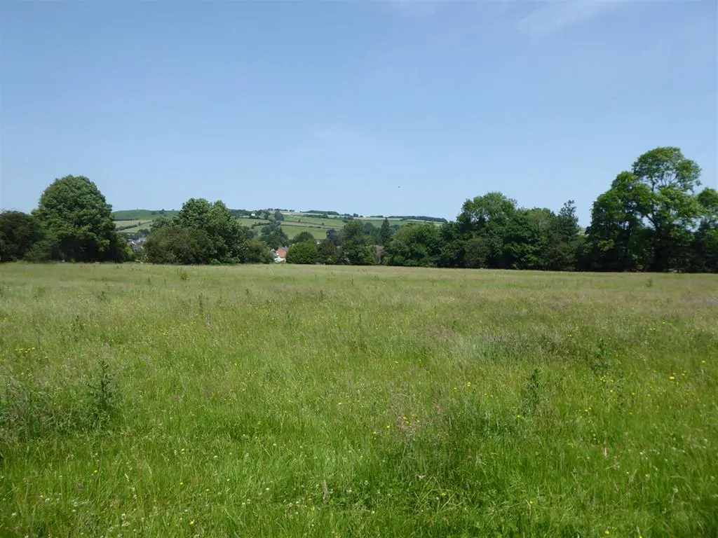
Situation and Description
This excellent development site lies on the south eastern side of the bustling and popular market town of Kington. The town currently has a population in the region of 3, 300 and offers an array of facilities with a modern Medical centre, large primary and secondary school, choice of shops, supermarket, leisure facilities and much more. The site also lies close to two main arterial routes, the A4111 to Hereford and A44 to Leominster and mid-Wales.
The proposed residential area extends to approximately 2.4 acres and is approximately 36% of the total application approved site area of 6.9 acres which includes open space which leads through meadowland to the River Arrow. This very attractive site has planning permission approved for up to 35 dwellings, creating an outstanding opportunity for investors and developers. A 106 Agreement has been approved and a detailed copy is available upon request. Herefordshire councils planning portal can provide further information quoting planning reference number 181494. With further details available from the agent upon request.
Directions:
W3W: ///intent.essays.wicked - Viewing of the site is at any reasonable time.
Prospective purchasers:
Upon submitting an offer, we will require by law, proof of ID for all buyers. A picture ID and a separate address ID together with proof of funding.
Any matters relating to rights of way should be checked with your solicitor or surveyor
Land at Headbrook, Kington, Herefordshire, HR5 3DY
Outline Planning Permission for Residential Development granted 17 August 2023 under reference 181494
A Planning Application / Planning Permission Details
1. Overall Land Area: 3.8 hectares / 9.4 acres
2. Boundaries:
Southern (Headbrook) - 76.5 meters / 252 feet plus a further 'set back' frontage 35.2 meters / 115.5 feet largely behind a ribbon of established generally older
residential and commercial properties.
Western - 54 meters / 177 feet behind established generally older residential and commercial properties alongside Headbrook and Bridge Street
Northern 92 meters / 302 feet of largely riverside meadows of the River Arrow
Eastern-38 meters / 125 feet of largely riverside meadows alongside a tributary brook of the River Arrow
3. Location: on Kington's south east side within 0.8 kilometers / 0.5 miles of Kington town centre, with more recent and fairly dense residential development to the south
4. Access: vehicle access through land adjacent to 45 Headbrook giving an approximate frontage of 28 meters/ 92 feet; the approved access plan (Doc 7_HK.Highways Access Plan OPP 0218)
shows a 5.5 metres width roadway and 2 x 2 metres footpaths through 45 Headbrook land with 54 meteres and 51 metres visibility splays.
5. Kington: an historic and locally important small market town of c. 3,300 population, providing a wide variety of services and facilities including shops; community and health provision;
nursery, primary and secondary schools; and local business and employment. It has a significant hinterland over North Herefordshire and across the Welsh border into Powys, with a wider
population estimate exceeding 20,000.
6. Proposed Residential Area: 1.0 hectares / 2.5 acres of floor free land; the residential area is approximately 36% of the total application / approved site area of 2.8 hectares / 6.9 acres
7. Outline Planning Permission; for up to 35 dwellings on the floor free residential area, with 'Local Green Space' including community facilities, walkways, enhanced landscaping and
environmental improvement areas on the remaining 1.8 hectares / 4.5 acres.
8. Housing Numbers: 35% of housing will be 'affordable' giving 23 'open market' units and 12 'affordable' units (it is expected that these will be on the basis of open market housing less a 'local
market discount' arrangement, quite often considered at 20%
9. Housing Mix: The OPP is based on a 2018 Local Housing Market Analysis, suggesting a typical mix of Open Market-1 x 1 BR; 5 x 2 BR; 11 X 3 BR; 4 x 4/5 BR. (Based on 21 units total; if based on
35 units overall and 23 Open Market units total, the mix would include 1 additional 2BR unit and 1 additional 3 BR unit)
Affordable- 1 x 1 BR; 5 x 2 BR; 11 x 3 BR; 4 x 4/5 BR. (Based on 21 units total; if based on 35 units overall, the affordable total would still remain at 12 units and the same mix)
10. Fully Detailed Information: This can be found in the original application's Planning Statement (Doc. 13) and Design & Access Statement (Doc. 14)
11. Section 106 Agreement: A brief summary of the basic breakdown of 'community' payments and commitment is:
Education-Based on Open Market dwellings only, £1377 each 2 BR flat; £2368 each 2/3 BR house; £3805 each 4 BR and over house
Headbook Land-A dedicated 5 meters wide land-strip to the rear of properties between 31 and 43 Headbrook (for increased rear garden space and off-road vehicle parking opportunity)
Hospital-A total of £18497
Management Company / Management Plan-Details of an appropriate method/s for implementing and managing the Local Green Space Land.
Monitoring Fee-A fee of £2500
Open Space Facilities-in accord with Herefordshire Council's Open Space Standards (fully detailed in the S106 document)
Phosphate Credits-A total of £62850, paid in advance (April 2023) by the applicant
Recycling-A payment of £80 per dwelling + 2 x Waste Bins per dwelling
Sports Provision-For Open Market properties only, £1425 per dwelling
Transport-Based on Open Market dwellings only, £1674 each 1 BR dwelling: £1966 each 2 BR dwelling; £2949 each 3 BR dwelling; £3932 each 4/5 BR dwelling
Affordable Housing-to be within the ambit of Herefordshire Council's 'Provision of Affordable Housing Technical Data to support the SPD-Planning Obligations 2008
Additional Payments-all payments will be index-linked and net of any VAT payable
B. Potential Future Development
1. Additional Land: there are 2 additional areas of potential development land, which we refer to as Phases 2 and 3
Phase 2-east of the approved access and residential area, with around 0.5 hectares / 1.3 acres within the 1000 year / Zone 1 Flood Free area, which as 35 dwellings per hectare gives around 15 dwellings; access is enabled and retained through the Phase 1 access.
Phase 3-west of the approved residential area and with direct access, enabled directly and retained through the Phase 1 access, with around 0.6 hectares / 1.5 acres within the Zone 1 area, which at 35 dwellings per hectare gives a potential of around 15 or more dwellings; this area is close to the outer limits of the Conservation area and is likely to require a fully detailed scheme with exceptional design and layout credentials, with the northern land beyond providing further Local Green Space and associated opportunities. PDA Planning has considered this area as having protentional for 55+ ages Residential Accommodation and/or Care Home or Specialist Health Accommodation, where densities might be increased, with such provision currently being encouraged by Government and other bodies nationally and locally. (Note: Land Registry number for this land is HE42424)
2. Access Provision-the approved access is accepted as being capable of providing for a minimum of 60 dwellings while there are established and potential easy pedestrian routes into the town and wider area and there is direct local public transport/'bus provision along Headbrook
C. Selected / Relevant Accompanying Documents submitted as part of the Outline Planning Application
Doc 1_HK A1.Site Location Plan
Doc 2_HK A2.Site Location Plan Wider Area
Doc 3_HK A3.Site Block Plan
Doc 9_HK A9.Flood Area Boundaries Plan
Doc 11_HK A11.Illustrative Site Layout Plan
Doc 13_HK B1.Planning Statement
Doc 14_HK B2.Design & Access Statement
Doc 23_HK D2.Design & Development Brief Statement
Doc 40_HK F1.Draft Design Layout Plan for PAE (Pre-Application Enquiry) (NB This was a preliminary scheme to illustrate how around 60 dwellings might be accommodated)
Doc 41_HK F2.Illustrative Site Layout Plan for OPA_OPP (Outline Planning Application/Outline Planning Permission)
Section 106 agreement (undersigned copy)
Note 1:
All measurements given are approximate and all documents and drawings are for Outline Planning Application purposes and should be considered preliminary at present to any future Detailed Planning Application/Approval of
Reserved Matters Application.
Note 2:
· All information and data within the Planning Statement and other documents has been gathered and considered in good faith and is considered to be correct at publication;
· At this Outline Planning Application stage, however, the authors cannot guarantee the content of the Statements and Reports or accompanying Documents, Drawings, Plans and Illustrative Material and any errors or omissions should be notified to the authors as soon as practicable for appropriate amendments, corrections and similar;
· The authors cannot be held responsible for any subsequent outcomes arising from any errors or omissions.
The information in this fact sheet has been supplied by PDA Planning and all information would need to be independently clarified by a Solicitor
