Land For Sale £500,000
A rare opportunity in this part of Kent, to buy productive arable land within the M25 - James Hickman, Land & Rural Property
#TheGardenOfEngland
Lot 3 of 3
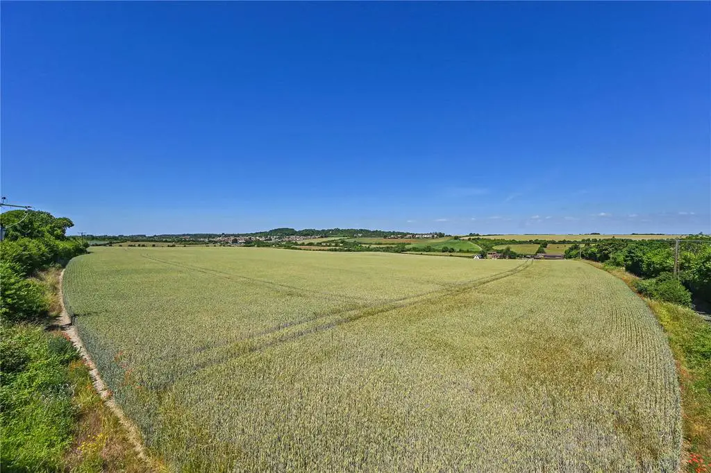
A productive parcel of arable farmland close to Hextable and Wilmington with road frontage and access.
About 44.61 acres (18.05 hectares)
Guide Price: £500,000 to £525,000
Situation
The land is located between the villages of Wilmington, Hawley and Hextable in north Kent, approximately 2.5miles south of Dartford. There is easy access to the M25 and A2 from the Darenth Interchange approximately 3.4 miles northeast, and to the M20 and M25 from Swanley Interchange approximately 3.6 miles south west.
The Farmland
The land extends to an area of about 285.75 acres (115.637 hectares) or thereabouts of predominately level arable land. The land is shown as a mixture of Grade II and Grade III on the Agricultural Land Classification Map. The soil is classified by the Cranfield Soil and AgriFood Institute as Soilscape 7 and characterised as freely draining slightly acid but base-rich soils of high fertility.
The land has been farmed in an arable rotation, with winter wheat, winter barley, spring barley, oil seed rape, linseed and peas grown within the last five years. A full cropping rotation is available on request.
Method of Sale
The land is offered for sale by Private Treaty with offers invited. However, in the event of several competing bids interested parties may be asked to submit their “best and final” offer.
The seller also reserves the right to offer the land by informal tender or public auction if the need arises.
The land is offered as a whole or in three Lots as coloured on the plans produced as part of these particulars and as described herein.
Lot 1: 162.33 acres (65.693 hectares)
A significant block of level Grade II and Grade III arable land. Road frontage on three boundaries and vehicular access from Shirehall Road to the north, and Barn End Lane to the west. There is internal access to Lot 2.
Lot 2: 78.81 acres (31.891 hectares)
Two parcels of Grade II and Grade III arable land. Road frontage and access to one field from Clement Street on the southern boundary. Internal access between the two parcels and with Lot 1.
Lot 3: 44.61 acres (18.053 hectares)
A single parcel of slightly sloping Grade II arable land with vehicular gated access from Gildenhill Road on the south east corner.
Overage, Clawback, Restrictions and Uplift
All Lots are sold subject to an overage agreement for a term of 30 years with a 30% uplift triggered by planning permission or permitted development for uses other than agriculture.
Tenancy and Possession
Lot 1 is offered freehold, with the exception of the indicative area shaded blue denoting a sale of a leasehold title. The leasehold land is on a 999-year lease with approx. 959 years remaining. A small parcel of the field is unregistered although it is understood to have been part of the field for circa 50 years.
Lot 2 is offered freehold.
Lot 3 is offered leasehold. The land is on two 999-years leases both with approx 959 years remaining.
A share farming agreement has recently expired and all 3 lots are offered with vacant possession.
Basic Payment Scheme
The land is eligible and registered to receive payments under the Basic Payment Scheme. Entitlements are available by separate negotiation if required.
Stewardship Schemes
We are not aware of any stewardship schemes upon the land.
Services
No services are currently connected to land.
Wayleaves, Easements, Rights of Way
The Property is being sold subject to and with the benefit of all rights including rights of way, whether public or private, light, support, easements and quasi easements and restrictive covenants and all existing and proposed wayleaves and easements for masts, towers, stays, cables, drains, communications, water and gas and other pipes whether referred to in these particulars or not.
Public footpaths cross Lot 1, Lot 2 & Lot 3. Plans are available on request
Designations
The land is located within the Green Belt and within North Kent Nitrate Vulnerable Zone (NVZ) 2021 to 2024.
Sporting Rights
These are included in the sale.
VAT
Any guide price quoted is exclusive of VAT. In the event that a sale of the properties or any part, or attached rights becomes a chargeable supply for the purposes of VAT, then such tax will be payable in addition.
Local Authority
All planning enquiries relating to any future planning or change of use of the land should be directed to Dartford Borough Council.
[use Contact Agent Button].
Website:
Photographs
Photographs were taken in June 2022.
Boundaries, Plans and Areas
The plans on these sales particulars and the acreages quoted are strictly for identification and guidance only. Interested parties are reminded that the land is sold in accordance with the owners Land Registry Title plans and must satisfy themselves as to the boundaries and the quantity of land being purchased.
The Purchaser(s) will be deemed to have full knowledge of all boundaries and any error or mistake shall not annul the sale or entitle any party to compensation thereof.
The specified areas are given for guidance only and without responsibility. Purchasers should not reply upon the stated areas as a statement or representation of fact but must satisfy themselves by inspection or otherwise.
Viewings
Strictly by confirmed appointment with Hobbs Parker on[use Contact Agent Button].
We ask all viewers to be vigilant.
Health and Safety
Prospective purchasers must have regard for their own safety during viewings. The Vendors and their agents do not accept any responsibility for any accident or injury as a result of viewings.
Our Ref: AEA210065
#TheGardenOfEngland
Lot 3 of 3
A productive parcel of arable farmland close to Hextable and Wilmington with road frontage and access.
About 44.61 acres (18.05 hectares)
Guide Price: £500,000 to £525,000
Situation
The land is located between the villages of Wilmington, Hawley and Hextable in north Kent, approximately 2.5miles south of Dartford. There is easy access to the M25 and A2 from the Darenth Interchange approximately 3.4 miles northeast, and to the M20 and M25 from Swanley Interchange approximately 3.6 miles south west.
The Farmland
The land extends to an area of about 285.75 acres (115.637 hectares) or thereabouts of predominately level arable land. The land is shown as a mixture of Grade II and Grade III on the Agricultural Land Classification Map. The soil is classified by the Cranfield Soil and AgriFood Institute as Soilscape 7 and characterised as freely draining slightly acid but base-rich soils of high fertility.
The land has been farmed in an arable rotation, with winter wheat, winter barley, spring barley, oil seed rape, linseed and peas grown within the last five years. A full cropping rotation is available on request.
Method of Sale
The land is offered for sale by Private Treaty with offers invited. However, in the event of several competing bids interested parties may be asked to submit their “best and final” offer.
The seller also reserves the right to offer the land by informal tender or public auction if the need arises.
The land is offered as a whole or in three Lots as coloured on the plans produced as part of these particulars and as described herein.
Lot 1: 162.33 acres (65.693 hectares)
A significant block of level Grade II and Grade III arable land. Road frontage on three boundaries and vehicular access from Shirehall Road to the north, and Barn End Lane to the west. There is internal access to Lot 2.
Lot 2: 78.81 acres (31.891 hectares)
Two parcels of Grade II and Grade III arable land. Road frontage and access to one field from Clement Street on the southern boundary. Internal access between the two parcels and with Lot 1.
Lot 3: 44.61 acres (18.053 hectares)
A single parcel of slightly sloping Grade II arable land with vehicular gated access from Gildenhill Road on the south east corner.
Overage, Clawback, Restrictions and Uplift
All Lots are sold subject to an overage agreement for a term of 30 years with a 30% uplift triggered by planning permission or permitted development for uses other than agriculture.
Tenancy and Possession
Lot 1 is offered freehold, with the exception of the indicative area shaded blue denoting a sale of a leasehold title. The leasehold land is on a 999-year lease with approx. 959 years remaining. A small parcel of the field is unregistered although it is understood to have been part of the field for circa 50 years.
Lot 2 is offered freehold.
Lot 3 is offered leasehold. The land is on two 999-years leases both with approx 959 years remaining.
A share farming agreement has recently expired and all 3 lots are offered with vacant possession.
Basic Payment Scheme
The land is eligible and registered to receive payments under the Basic Payment Scheme. Entitlements are available by separate negotiation if required.
Stewardship Schemes
We are not aware of any stewardship schemes upon the land.
Services
No services are currently connected to land.
Wayleaves, Easements, Rights of Way
The Property is being sold subject to and with the benefit of all rights including rights of way, whether public or private, light, support, easements and quasi easements and restrictive covenants and all existing and proposed wayleaves and easements for masts, towers, stays, cables, drains, communications, water and gas and other pipes whether referred to in these particulars or not.
Public footpaths cross Lot 1, Lot 2 & Lot 3. Plans are available on request
Designations
The land is located within the Green Belt and within North Kent Nitrate Vulnerable Zone (NVZ) 2021 to 2024.
Sporting Rights
These are included in the sale.
VAT
Any guide price quoted is exclusive of VAT. In the event that a sale of the properties or any part, or attached rights becomes a chargeable supply for the purposes of VAT, then such tax will be payable in addition.
Local Authority
All planning enquiries relating to any future planning or change of use of the land should be directed to Dartford Borough Council.
[use Contact Agent Button].
Website:
Photographs
Photographs were taken in June 2022.
Boundaries, Plans and Areas
The plans on these sales particulars and the acreages quoted are strictly for identification and guidance only. Interested parties are reminded that the land is sold in accordance with the owners Land Registry Title plans and must satisfy themselves as to the boundaries and the quantity of land being purchased.
The Purchaser(s) will be deemed to have full knowledge of all boundaries and any error or mistake shall not annul the sale or entitle any party to compensation thereof.
The specified areas are given for guidance only and without responsibility. Purchasers should not reply upon the stated areas as a statement or representation of fact but must satisfy themselves by inspection or otherwise.
Viewings
Strictly by confirmed appointment with Hobbs Parker on[use Contact Agent Button].
We ask all viewers to be vigilant.
Health and Safety
Prospective purchasers must have regard for their own safety during viewings. The Vendors and their agents do not accept any responsibility for any accident or injury as a result of viewings.
Our Ref: AEA210065