Land For Sale £325,000
Ayton Woodland extending to approximately 35.54 ha (87.82 acres of mixed conifer and broadleaf woodland
A number of good quality forest roads lie within the woodland itself. It is understood the access rights exist over the woodland track lying on the southerly boundary, enabling the extraction of timber and access for contractors for planting and routine maintenance.
A former quarry is located within the subjects, in the vicinity of the former sawmill and ice house. It is understood that the quarry was used to source the material for the roads, and during recent harvesting works as a site for storing timber prior to it being hauled from site.
The owners of Barclayfield are understood to have a right of access for vehicles across the property, as are the owners of Pitmedden Forest to the south, in the latter case for the extraction of timber.
Land Classification and Soil Type / Association
The soils are classified by The James Hutton Institute as predominantly brown soils from the Sourhope Soil Association.
Land Capability for forestry is understood to be as follows :-
F2—9.12 hectares (land with very good flexibility for the growth and management of tree crops).
F6—26.42 hectares (land with very limited flexibility for the growth and management of tree crops).
Altitude and Aspect
The woodland lies between the 35 and 177 metre contours above sea level (approximately). The woodland rises quite steeply in places to a saddle at Crowclag (177 m) and has therefore both a northerly and southerly aspect.
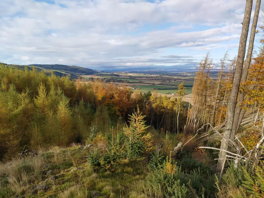
Ayton Woodland is in a good condition with small areas of localised windblow in compartment 1a1 adjacent to the most recent felling. Compartment 1b planted in 1951 with Norway spruce offers the best productive timber within the woodland. The areas (compartments 1c1 and 1c2) that were restocked in 2012 have put on good growth and are now fully established. The areas of mixed broadleaves offer greater species diversity to the woodland.
The Yield class for the areas of Larch being approximately YC 8 -10, Norway spruce YC being 16-18 and the areas of mixed broadleaves being YC4-6. These are all about average for these species.
Some of the Ash have Ash Dieback. There are no other signs of disease present. The open space is mainly located around the internal access tracks and turning areas.
Ayton woodland is split between commercial and amenity woodland. Approximately 42% is commercial woodland mainly conifer species and the remaining 58% is amenity woodland consisting of mixed broadleaves and open ground.
Drainage and Water Supplies / Irrigation
Watercourses lie on the south, east and westerly boundaries. A water intake was noted on the burn at the southerly march adjacent to the access track to Barclayfield. It is not known if this supply feeds any property or is within the area of ownership.
Woodland Size and Fencing
The woodland extends to approximately 35.54 hectares (87.82 acres) and lies in a single block.
The woodlands are not fully enclosed. The combination of post and wire, stone dyke and metal rail fences lies on the northerly boundary. The easterly and westerly boundary is open, as is part of the southern boundary, the balance being demarcated by a stone dyke.
Grants / Subsidies / IACS / Other Schemes
We are not aware of the subjects receiving any woodland or other grants.
Sporting
We understand that the sporting rights are currently not being exercised, but have in the past been let out ,and that on average 3 to 4 roe deer have been culled annually.
Sporting rates are levied on the woodland, but we do not have a copy of the rates documentation. The Subjects may be eligible for reliefs and any rates being levied are unlikely to be significant.
Agricultural, Conservation and Environmental Designations
The subjects are designated as Less Favoured Area (Seriously Disadvantaged, on the SGRPID portal. We are not aware of any conservation or environmental designations.
Contamination, Ground Conditions and Flooding
A derelict former sawmill and ice house are located on the subject. Both properties are in a state of disrepair. It is assumed that there are no contamination issues with these buildings.
A former quarry is located within the subjects, in the vicinity of the former sawmill and ice house. It is understood that the quarry was used to source the material for the roads and as a site for storing timber prior to being hauled from site. With the exception of the former quarry, it is not known if any mining or other issues of ground instability which may affect the property or the locality.
It is not known if any other previous use which would have resulted in the land being included in any register of contaminated land. No investigations into such matters have been carried out. No evidence of invasive / non-native species or asbestos containing materials were noted.
The flood risk map does not indicate any issues of flooding from river or surface water. The risk of flooding reported does not, however, take into account any flood defences which may be in place now or in the future or impact any change of use.
While the topography of the subjects results in steep slopes good quality forest roads have been created enabling the extraction of timber and access for contractors for harvesting, planting and routine maintenance.
Burdens and Third Party Rights
A number of informal footpaths are noted through the woodland, which are used by the public for walking and cycling. Core Path ABNY/105 crosses the woodland, from Abernethy Glen road at Glencroft to ABNY/100 at Preaching How, via Barclayfield.
A water intake was noted on the burn at the southerly march adjacent to the access track to Barclayfield. It is not known if this supply feeds any property or is within the area of ownership.
The owners of Barclayfield are understood to have a right of access for vehicles across the property, as are the owners of Pitmedden Forest to the south, in the latter case for the extraction of timber. It is not known if there are any other burdens or third party rights.
The property is sold under the conditions of the Title Deeds, subject to all Servitude Rights, burdens, reservations, and wayleaves including rights of way and rights of access howsoever constituted.
The purchaser shall be held responsible to satisfy themselves as to the nature of all burdens, should they exist. Further details can be obtained via the selling agents. Title deeds will be exhibited to the purchaser’s legal agents for examination.
Archaeology
No archaeological features have been identified on site.
Minerals
Mineral rights are included, except as provided for by statute.
Plans and Areas
These are based on the Ordnance Survey and are for reference only. The purchaser shall be deemed to have satisfied themselves as to their accuracy and any error shall not annul the sale or entitle any part to compensation in respect thereof.
VAT
In the event that the seller has elected to tax, VAT may be payable on the purchase price.
Scottish Government Rural Payments and Inspections Directorate (SGRPID)
Strathearn House, Broxden Business Park, Lamberkine Drive, Perth PH1 1RX
Local Scottish Forestry Office
Perth and Argyll Conservancy, Upper Battleby, Redgorton, Perth PH1 3EN
Local Authority
Perth & Kinross Council, 2 High Street, Perth PH1 5PH
A number of good quality forest roads lie within the woodland itself. It is understood the access rights exist over the woodland track lying on the southerly boundary, enabling the extraction of timber and access for contractors for planting and routine maintenance.
A former quarry is located within the subjects, in the vicinity of the former sawmill and ice house. It is understood that the quarry was used to source the material for the roads, and during recent harvesting works as a site for storing timber prior to it being hauled from site.
The owners of Barclayfield are understood to have a right of access for vehicles across the property, as are the owners of Pitmedden Forest to the south, in the latter case for the extraction of timber.
Land Classification and Soil Type / Association
The soils are classified by The James Hutton Institute as predominantly brown soils from the Sourhope Soil Association.
Land Capability for forestry is understood to be as follows :-
F2—9.12 hectares (land with very good flexibility for the growth and management of tree crops).
F6—26.42 hectares (land with very limited flexibility for the growth and management of tree crops).
Altitude and Aspect
The woodland lies between the 35 and 177 metre contours above sea level (approximately). The woodland rises quite steeply in places to a saddle at Crowclag (177 m) and has therefore both a northerly and southerly aspect.
Ayton Woodland is in a good condition with small areas of localised windblow in compartment 1a1 adjacent to the most recent felling. Compartment 1b planted in 1951 with Norway spruce offers the best productive timber within the woodland. The areas (compartments 1c1 and 1c2) that were restocked in 2012 have put on good growth and are now fully established. The areas of mixed broadleaves offer greater species diversity to the woodland.
The Yield class for the areas of Larch being approximately YC 8 -10, Norway spruce YC being 16-18 and the areas of mixed broadleaves being YC4-6. These are all about average for these species.
Some of the Ash have Ash Dieback. There are no other signs of disease present. The open space is mainly located around the internal access tracks and turning areas.
Ayton woodland is split between commercial and amenity woodland. Approximately 42% is commercial woodland mainly conifer species and the remaining 58% is amenity woodland consisting of mixed broadleaves and open ground.
Drainage and Water Supplies / Irrigation
Watercourses lie on the south, east and westerly boundaries. A water intake was noted on the burn at the southerly march adjacent to the access track to Barclayfield. It is not known if this supply feeds any property or is within the area of ownership.
Woodland Size and Fencing
The woodland extends to approximately 35.54 hectares (87.82 acres) and lies in a single block.
The woodlands are not fully enclosed. The combination of post and wire, stone dyke and metal rail fences lies on the northerly boundary. The easterly and westerly boundary is open, as is part of the southern boundary, the balance being demarcated by a stone dyke.
Grants / Subsidies / IACS / Other Schemes
We are not aware of the subjects receiving any woodland or other grants.
Sporting
We understand that the sporting rights are currently not being exercised, but have in the past been let out ,and that on average 3 to 4 roe deer have been culled annually.
Sporting rates are levied on the woodland, but we do not have a copy of the rates documentation. The Subjects may be eligible for reliefs and any rates being levied are unlikely to be significant.
Agricultural, Conservation and Environmental Designations
The subjects are designated as Less Favoured Area (Seriously Disadvantaged, on the SGRPID portal. We are not aware of any conservation or environmental designations.
Contamination, Ground Conditions and Flooding
A derelict former sawmill and ice house are located on the subject. Both properties are in a state of disrepair. It is assumed that there are no contamination issues with these buildings.
A former quarry is located within the subjects, in the vicinity of the former sawmill and ice house. It is understood that the quarry was used to source the material for the roads and as a site for storing timber prior to being hauled from site. With the exception of the former quarry, it is not known if any mining or other issues of ground instability which may affect the property or the locality.
It is not known if any other previous use which would have resulted in the land being included in any register of contaminated land. No investigations into such matters have been carried out. No evidence of invasive / non-native species or asbestos containing materials were noted.
The flood risk map does not indicate any issues of flooding from river or surface water. The risk of flooding reported does not, however, take into account any flood defences which may be in place now or in the future or impact any change of use.
While the topography of the subjects results in steep slopes good quality forest roads have been created enabling the extraction of timber and access for contractors for harvesting, planting and routine maintenance.
Burdens and Third Party Rights
A number of informal footpaths are noted through the woodland, which are used by the public for walking and cycling. Core Path ABNY/105 crosses the woodland, from Abernethy Glen road at Glencroft to ABNY/100 at Preaching How, via Barclayfield.
A water intake was noted on the burn at the southerly march adjacent to the access track to Barclayfield. It is not known if this supply feeds any property or is within the area of ownership.
The owners of Barclayfield are understood to have a right of access for vehicles across the property, as are the owners of Pitmedden Forest to the south, in the latter case for the extraction of timber. It is not known if there are any other burdens or third party rights.
The property is sold under the conditions of the Title Deeds, subject to all Servitude Rights, burdens, reservations, and wayleaves including rights of way and rights of access howsoever constituted.
The purchaser shall be held responsible to satisfy themselves as to the nature of all burdens, should they exist. Further details can be obtained via the selling agents. Title deeds will be exhibited to the purchaser’s legal agents for examination.
Archaeology
No archaeological features have been identified on site.
Minerals
Mineral rights are included, except as provided for by statute.
Plans and Areas
These are based on the Ordnance Survey and are for reference only. The purchaser shall be deemed to have satisfied themselves as to their accuracy and any error shall not annul the sale or entitle any part to compensation in respect thereof.
VAT
In the event that the seller has elected to tax, VAT may be payable on the purchase price.
Scottish Government Rural Payments and Inspections Directorate (SGRPID)
Strathearn House, Broxden Business Park, Lamberkine Drive, Perth PH1 1RX
Local Scottish Forestry Office
Perth and Argyll Conservancy, Upper Battleby, Redgorton, Perth PH1 3EN
Local Authority
Perth & Kinross Council, 2 High Street, Perth PH1 5PH