Land For Sale £1,300,000
A rare opportunity to acquire development land, located within the attractive village of Flookburgh, benefitting from outline planning permission for the construction of 32 residential dwellings.
Extending in all to approximately 1.174 hectares (2.90 acres)
Particulars
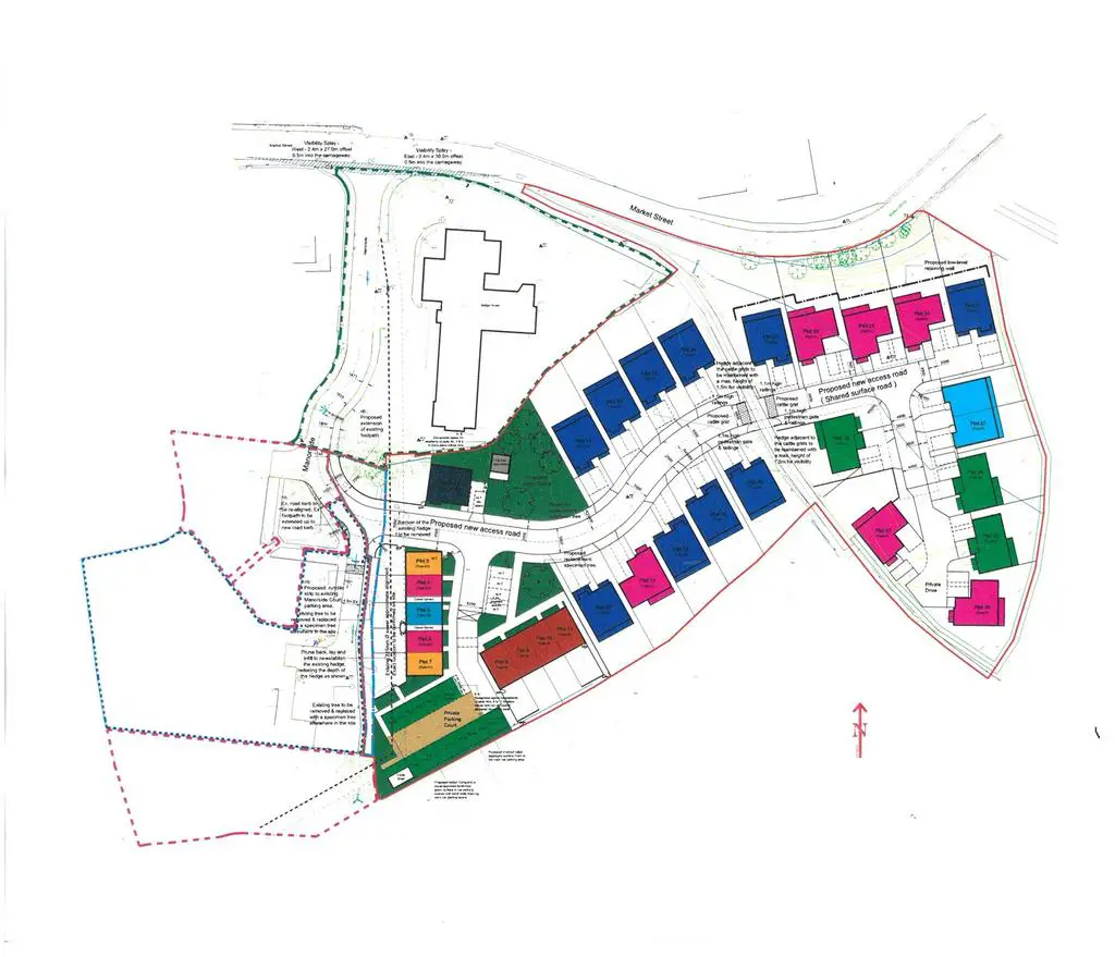
The location and extent of the site is shown edged red on the plan attached to these particulars. In all the site extends to approximately 1.17 hectares (2.90 acres). The site is presently split into two separate field parcels. A green lane transects the two fields, running from the B5277 and providing access to the separately owned, agricultural fields to the south of the subject property.
The site is generally level in nature with mature hedgerows forming all boundaries.
The property’s location, on the eastern periphery of Flookburgh, provides great access to the wide range local amenities, including: doctor’s surgery, pharmacy, opticians, convenience store, public house and primary school. There are regular local bus services connecting Flookburgh and Cark to Grange-over-Sands, via Allithwaite and a train station at Cark connecting to Oxenholme to the main line to Manchester and Preston.
Planning
The site has the benefit of outline planning permission for the development of 32 residential dwellings providing 3,655m2 of development (excluding garages). Planning permission was granted on 13th January 2023 under planning reference SL/2021/0991.
The permission details that the development must provide 11 affordable housing units (35%) with a tenure mix of 5 affordable rent and 6 discounted sale.
Further information is available via the technical pack, accessed upon request. However, Prospective buyers are recommended to make their own enquiries at the Planning Offices of South Lakeland District Council, details of which are provided below.
Technical Information
In the first instance interested parties are requested to formally register their interest with the selling agents, who will thereafter provide an electronic link to download the technical
information available. The information includes, but is not limited to, the following:-
1. Geo Environmental Phase 1 Desktop &
Phase 2 of part (historic)
2. Floor Plans & Elevations for all units
3. Landscape Report
4. Noise Survey
5. Tree Survey
6. Landscape Drawing [Matching Bio reports]
7. Swept Path Analysis
8. Biodiversity Impact Assessment
9. Drainage Strategy + Soakaway +
Percolation
?? ADDITIONAL INFORMATION TO ADD
Potential enhancements
The opportunity presents a number of potential enhancements including:
Improved development density to 35 units in accordance with the development plan policy
Viability assessment to improve the affordable percentage and/or mix
Interested parties are advised to make their own enquiries but further information can be provided upon request.
Directions
From the A590 heading west at the Meathop roundabout take the B5277 to Grange. Continue through the town centre heading west to Allithwaite, continue on the B5277 for approximately 1.5 miles to Flookburgh. The land is located on your left, immediately after crossing the railway bridge on entering Flookburgh.
What3Words: shiny.including.princely
Grid Reference: SD[use Contact Agent Button]
Location
The development site is located on the eastern edge of Flookburgh, within the Cartmel peninsula of Cumbria. Approximately 3 miles west of Grange-over-Sands and 2.5 miles south of Cartmel. Junction 36 of the M6 motorway lies 16 miles to the east, proving access to the wider national motorway network. There is a railway station in nearby Cark-in-Cartmel and Grange-over-Sands.
Services
Tenure
Freehold. Benefitting from vacant possession.
Local Planning Council
Westmorland and Furness Council -[use Contact Agent Button].
Services
It is understood that all mains services are available to the site from Manorside.
Interested parties are advised to satisfy themselves in regards to their suitability.
Access
Access to the site is currently taken via the aforementioned green lane that transects the two field parcels. This however is not sufficient to allow future residential access.
As illustrated on the attached site plans, access to the developed site is to be provided via Manorside. The access off Manorside has been agreed with Local Council.
Method of Sale
The property is offered for sale via Private Treaty (structured offers considered).
Selling Agents:
H&H Land and Estates, Cumbria Tourism Business Centre, Windermere Road, Staveley, LA8 9PL
Eckersleys, 25A Winckley Square, Preston, PR1 3JJ
VAT
We understand that the purchase price will be subject to VAT
Wayleaves and Easmements
he properties are sold subject to and with the benefit of any existing easements, wayleaves and rights of way. The sale is subject to all the existing rights of way, drainage, light, air support and other easements and quasi-easements and outgoings whether mentioned in these particulars or not.
Sale Plan
The Sale Plan has been prepared for the convenience of prospective purchasers. They are deemed to be correct and any error, omission or misstatement shall not affect the sale. The purchasers must satisfy themselves as to its accuracy.
Viewing
The land can be viewed at any reasonable time providing a set of these particulars are in hand.
Extending in all to approximately 1.174 hectares (2.90 acres)
Particulars
The location and extent of the site is shown edged red on the plan attached to these particulars. In all the site extends to approximately 1.17 hectares (2.90 acres). The site is presently split into two separate field parcels. A green lane transects the two fields, running from the B5277 and providing access to the separately owned, agricultural fields to the south of the subject property.
The site is generally level in nature with mature hedgerows forming all boundaries.
The property’s location, on the eastern periphery of Flookburgh, provides great access to the wide range local amenities, including: doctor’s surgery, pharmacy, opticians, convenience store, public house and primary school. There are regular local bus services connecting Flookburgh and Cark to Grange-over-Sands, via Allithwaite and a train station at Cark connecting to Oxenholme to the main line to Manchester and Preston.
Planning
The site has the benefit of outline planning permission for the development of 32 residential dwellings providing 3,655m2 of development (excluding garages). Planning permission was granted on 13th January 2023 under planning reference SL/2021/0991.
The permission details that the development must provide 11 affordable housing units (35%) with a tenure mix of 5 affordable rent and 6 discounted sale.
Further information is available via the technical pack, accessed upon request. However, Prospective buyers are recommended to make their own enquiries at the Planning Offices of South Lakeland District Council, details of which are provided below.
Technical Information
In the first instance interested parties are requested to formally register their interest with the selling agents, who will thereafter provide an electronic link to download the technical
information available. The information includes, but is not limited to, the following:-
1. Geo Environmental Phase 1 Desktop &
Phase 2 of part (historic)
2. Floor Plans & Elevations for all units
3. Landscape Report
4. Noise Survey
5. Tree Survey
6. Landscape Drawing [Matching Bio reports]
7. Swept Path Analysis
8. Biodiversity Impact Assessment
9. Drainage Strategy + Soakaway +
Percolation
?? ADDITIONAL INFORMATION TO ADD
Potential enhancements
The opportunity presents a number of potential enhancements including:
Improved development density to 35 units in accordance with the development plan policy
Viability assessment to improve the affordable percentage and/or mix
Interested parties are advised to make their own enquiries but further information can be provided upon request.
Directions
From the A590 heading west at the Meathop roundabout take the B5277 to Grange. Continue through the town centre heading west to Allithwaite, continue on the B5277 for approximately 1.5 miles to Flookburgh. The land is located on your left, immediately after crossing the railway bridge on entering Flookburgh.
What3Words: shiny.including.princely
Grid Reference: SD[use Contact Agent Button]
Location
The development site is located on the eastern edge of Flookburgh, within the Cartmel peninsula of Cumbria. Approximately 3 miles west of Grange-over-Sands and 2.5 miles south of Cartmel. Junction 36 of the M6 motorway lies 16 miles to the east, proving access to the wider national motorway network. There is a railway station in nearby Cark-in-Cartmel and Grange-over-Sands.
Services
Tenure
Freehold. Benefitting from vacant possession.
Local Planning Council
Westmorland and Furness Council -[use Contact Agent Button].
Services
It is understood that all mains services are available to the site from Manorside.
Interested parties are advised to satisfy themselves in regards to their suitability.
Access
Access to the site is currently taken via the aforementioned green lane that transects the two field parcels. This however is not sufficient to allow future residential access.
As illustrated on the attached site plans, access to the developed site is to be provided via Manorside. The access off Manorside has been agreed with Local Council.
Method of Sale
The property is offered for sale via Private Treaty (structured offers considered).
Selling Agents:
H&H Land and Estates, Cumbria Tourism Business Centre, Windermere Road, Staveley, LA8 9PL
Eckersleys, 25A Winckley Square, Preston, PR1 3JJ
VAT
We understand that the purchase price will be subject to VAT
Wayleaves and Easmements
he properties are sold subject to and with the benefit of any existing easements, wayleaves and rights of way. The sale is subject to all the existing rights of way, drainage, light, air support and other easements and quasi-easements and outgoings whether mentioned in these particulars or not.
Sale Plan
The Sale Plan has been prepared for the convenience of prospective purchasers. They are deemed to be correct and any error, omission or misstatement shall not affect the sale. The purchasers must satisfy themselves as to its accuracy.
Viewing
The land can be viewed at any reasonable time providing a set of these particulars are in hand.
